
CTET Exam - Paper 2 - Fundamentals Of Geography Earth And Its Systems
CTET exam Paper 2 preparation with Clear Cutoff
by Clear Cutoff
Showing 20 of 20 questions
Question 1
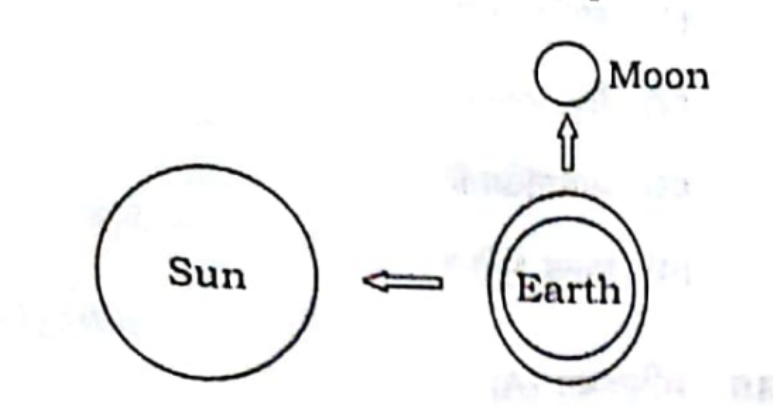
Observe carefully the location of the sun, earth and moon in the given diagram and tell what it depicts :
Choose an answer to reveal your result and explanation.
Answer & Explanation
The given diagram depicts a scenario that corresponds to Option 4: Neap tide. Let's explore why this is the correct answer and why the other options are incorrect.
Explanation for Option 4: Neap Tide
Neap tides occur when the gravitational forces of the moon and the sun are perpendicular to each other with respect to the Earth. This typically happens during the first and third quarters of the moon. In this alignment, the gravitational pull of the moon and the sun partially cancel each other out, resulting in the least difference between high and low tides. The diagram likely shows the Earth, moon, and sun forming a right angle, which is characteristic of neap tides. This alignment reduces the tidal range, leading to weaker tides.
Why Other Options are Incorrect
-
Solar Eclipse: A solar eclipse occurs when the moon passes directly between the Earth and the sun, casting a shadow on the Earth. This alignment requires the sun, moon, and Earth to be in a straight line, with the moon in the middle. The diagram does not depict this linear alignment, so it cannot represent a solar eclipse.
-
Lunar Eclipse: A lunar eclipse happens when the Earth is directly between the sun and the moon, causing the Earth's shadow to fall on the moon. This requires the sun, Earth, and moon to be in a straight line, with the Earth in the middle. The diagram does not show this alignment, so it cannot be a lunar eclipse.
-
Spring Tide: Spring tides occur when the sun, moon, and Earth are aligned in a straight line, either during a new moon or a full moon. This alignment results in the combined gravitational pull of the moon and the sun, leading to the highest high tides and the lowest low tides. The diagram does not depict this linear alignment, so it cannot represent a spring tide.
In conclusion, the diagram's depiction of the sun, Earth, and moon forming a right angle supports the occurrence of neap tides, making Option 4 the correct answer.
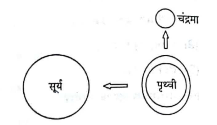
दिए गए आरेख में सूर्य, पृथ्वी और चंद्रमा की स्थिति को ध्यान से देखिए और बताइए कि यह क्या दर्शाता है :
Choose an answer to reveal your result and explanation.
Answer & Explanation
दिए गए आरेख में सूर्य, पृथ्वी और चंद्रमा की स्थिति को ध्यान से देखते हुए, यह स्थिति लघु ज्वार-भाटा को दर्शाती है। आइए समझते हैं कि क्यों विकल्प 4 सही है और अन्य विकल्प क्यों गलत हैं:
-
लघु ज्वार-भाटा (Option 4):
- लघु ज्वार-भाटा तब होता है जब सूर्य और चंद्रमा पृथ्वी के साथ समकोण बनाते हैं। इस स्थिति में, सूर्य और चंद्रमा के गुरुत्वाकर्षण बल एक-दूसरे के प्रभाव को कम करते हैं, जिससे ज्वार की ऊँचाई कम हो जाती है। आरेख में दिखाए गए स्थिति में, सूर्य और चंद्रमा पृथ्वी के साथ समकोण पर हैं, जो लघु ज्वार-भाटा की स्थिति को दर्शाता है।
-
सूर्य-ग्रहण (Option 1):
- सूर्य-ग्रहण तब होता है जब चंद्रमा सूर्य और पृथ्वी के बीच आ जाता है, जिससे सूर्य का प्रकाश पृथ्वी पर नहीं पहुँच पाता। आरेख में ऐसी स्थिति नहीं दिखाई गई है, इसलिए यह विकल्प गलत है।
-
चंद्र-ग्रहण (Option 2):
- चंद्र-ग्रहण तब होता है जब पृथ्वी सूर्य और चंद्रमा के बीच आ जाती है, जिससे पृथ्वी की छाया चंद्रमा पर पड़ती है। आरेख में यह स्थिति नहीं है, इसलिए यह विकल्प भी गलत है।
-
बृहत् ज्वार-भाटा (Option 3):
- बृहत् ज्वार-भाटा तब होता है जब सूर्य, पृथ्वी और चंद्रमा एक सीधी रेखा में होते हैं, जिससे ज्वार की ऊँचाई अधिक हो जाती है। आरेख में सूर्य और चंद्रमा पृथ्वी के साथ समकोण पर हैं, न कि एक सीधी रेखा में, इसलिए यह विकल्प गलत है।
इस प्रकार, आरेख में दर्शाई गई स्थिति लघु ज्वार-भाटा को सही रूप से दर्शाती है, और यही कारण है कि विकल्प 4 सही है।
Question 2
Which one of the following continents is smallest in size ?
Choose an answer to reveal your result and explanation.
Answer & Explanation
Option 1, Australia, is the correct answer as the smallest continent in size. Here is a detailed explanation supporting this choice:
-
Australia: Australia is the smallest continent in the world, covering an area of approximately 7.7 million square kilometers. It is unique in that it is both a country and a continent. Its size is significantly smaller compared to other continents, making it the smallest by land area.
-
South America: South America is much larger than Australia, with an area of about 17.8 million square kilometers. It is the fourth largest continent and includes a diverse range of geographical features, from the Amazon rainforest to the Andes mountains.
-
Africa: Africa is the second largest continent, covering approximately 30.2 million square kilometers. It is vastly larger than Australia and is known for its diverse ecosystems, including deserts, savannas, and tropical rainforests.
-
Europe: Europe, while smaller than Africa and South America, is still larger than Australia. It covers an area of about 10.2 million square kilometers. Europe is known for its rich history and cultural diversity, but in terms of land area, it surpasses Australia.
In conclusion, Australia is the smallest continent by land area, which is why Option 1 is the correct answer. The other options, South America, Africa, and Europe, are all larger in size compared to Australia, justifying why they are incorrect in this context.
निम्नलिखित में से कौन-सा महाद्वीप आकार में सबसे छोटा है ?
Choose an answer to reveal your result and explanation.
Answer & Explanation
ऑस्ट्रेलिया आकार में सबसे छोटा महाद्वीप है, और इसे सही विकल्प के रूप में चुना गया है। आइए इसे विस्तार से समझें:
-
ऑस्ट्रेलिया (Option 1): ऑस्ट्रेलिया महाद्वीप का कुल क्षेत्रफल लगभग 7.7 मिलियन वर्ग किलोमीटर है, जो इसे आकार में सबसे छोटा महाद्वीप बनाता है। यह एकमात्र महाद्वीप है जो एक ही देश के रूप में भी जाना जाता है। इसकी भौगोलिक स्थिति और सीमित क्षेत्रफल इसे अन्य महाद्वीपों की तुलना में छोटा बनाता है।
-
दक्षिण अमेरिका (Option 2): दक्षिण अमेरिका का क्षेत्रफल लगभग 17.8 मिलियन वर्ग किलोमीटर है, जो ऑस्ट्रेलिया से काफी बड़ा है। इसमें कई देश शामिल हैं और यह आकार में चौथा सबसे बड़ा महाद्वीप है।
-
अफ्रीका (Option 3): अफ्रीका का क्षेत्रफल लगभग 30.2 मिलियन वर्ग किलोमीटर है, जो इसे आकार में दूसरा सबसे बड़ा महाद्वीप बनाता है। यह ऑस्ट्रेलिया से कई गुना बड़ा है।
-
यूरोप (Option 4): यूरोप का क्षेत्रफल लगभग 10.2 मिलियन वर्ग किलोमीटर है। यह ऑस्ट्रेलिया से बड़ा है, हालांकि यह अन्य महाद्वीपों की तुलना में छोटा है, लेकिन फिर भी ऑस्ट्रेलिया से बड़ा है।
इस प्रकार, ऑस्ट्रेलिया आकार में सबसे छोटा महाद्वीप है, और यही कारण है कि विकल्प 1 सही उत्तर है। अन्य विकल्प आकार में ऑस्ट्रेलिया से बड़े हैं, इसलिए वे सही नहीं हो सकते।
Question 3
Statement (A) : Only one side of the moon is visible to us on Earth.
Statement (B): The moon moves around the Earth in about 27 days and takes exactly the same time to complete 1 spin.
Select the correct option from the given alternatives.
Choose an answer to reveal your result and explanation.
Answer & Explanation
Option 1 is the correct answer because both Statement (A) and Statement (B) are true, and Statement (B) provides the correct explanation for Statement (A).
-
Explanation of Statement (A):
- Statement (A) asserts that only one side of the moon is visible to us on Earth. This is a well-known phenomenon called "synchronous rotation" or "tidal locking." It means that the moon rotates on its axis at the same rate that it orbits the Earth, resulting in the same hemisphere always facing the Earth.
-
Explanation of Statement (B):
- Statement (B) states that the moon moves around the Earth in about 27 days and takes exactly the same time to complete one spin. This is true and is the reason for the synchronous rotation mentioned in Statement (A). The moon's orbital period and rotational period are both approximately 27.3 days, which is why we only see one side of the moon from Earth.
-
Why Statement (B) is the correct explanation for Statement (A):
- The fact that the moon takes the same amount of time to rotate on its axis as it does to orbit the Earth (as stated in Statement (B)) is precisely why only one side of the moon is visible from Earth (as stated in Statement (A)). This synchronization is the reason for the phenomenon described in Statement (A).
-
Why the other options are incorrect:
- Option 2: This option suggests that both statements are true, but (B) is not the correct explanation for (A). However, as explained, (B) directly explains why (A) is true, making this option incorrect.
- Option 3: This option claims that (A) is true, but (B) is false. Since (B) is factually accurate, this option is incorrect.
- Option 4: This option suggests that (A) is false, but (B) is true. Since (A) is a well-documented phenomenon, this option is incorrect.
In conclusion, Option 1 is the correct choice because it accurately reflects the relationship between the moon's rotation and orbit, explaining why only one side is visible from Earth.
कथन (A) : पृथ्वी से हमें चन्द्रमा का केवल एक ही भाग दिखाई पड़ता है।
कथन (B) : चन्द्रमा पृथ्वी का एक चक्कर लगभग 27 दिनों में पूरा करता है और लगभग इतने ही समय में वह अपने अक्ष पर एक चक्कर भी पूरा करता है।
नीचे दिए गए विकल्पों में से सही विकल्प का चयन कीजिए :
Choose an answer to reveal your result and explanation.
Answer & Explanation
कथन (A) और (B) दोनों सही हैं और (B) सही व्याख्या है (A) की। आइए इसे विस्तार से समझते हैं:
-
कथन (A) का विश्लेषण: पृथ्वी से हमें चन्द्रमा का केवल एक ही भाग दिखाई पड़ता है। यह कथन सही है क्योंकि चन्द्रमा का एक ही भाग हमेशा पृथ्वी की ओर रहता है। इसे "टाइडल लॉकिंग" कहा जाता है, जहां चन्द्रमा की घूर्णन अवधि और उसकी परिक्रमा अवधि समान होती है।
-
कथन (B) का विश्लेषण: चन्द्रमा पृथ्वी का एक चक्कर लगभग 27 दिनों में पूरा करता है और लगभग इतने ही समय में वह अपने अक्ष पर एक चक्कर भी पूरा करता है। यह कथन भी सही है। चन्द्रमा की परिक्रमा अवधि और उसकी घूर्णन अवधि लगभग 27.3 दिन है, जिसके कारण वह पृथ्वी की ओर हमेशा एक ही भाग दिखाता है।
-
क्यों (B) सही व्याख्या है (A) की: चन्द्रमा की परिक्रमा और घूर्णन अवधि के समान होने के कारण ही हमें चन्द्रमा का एक ही भाग दिखाई देता है। यह "टाइडल लॉकिंग" का परिणाम है, जो (B) में वर्णित तथ्य के कारण होता है। इसलिए, (B) सही व्याख्या है (A) की।
-
अन्य विकल्पों का खंडन:
- विकल्प 2: यह विकल्प गलत है क्योंकि (B) सही व्याख्या है (A) की, जैसा कि ऊपर समझाया गया है।
- विकल्प 3: यह विकल्प गलत है क्योंकि (B) भी सही है, न कि गलत।
- विकल्प 4: यह विकल्प गलत है क्योंकि (A) भी सही है, न कि गलत।
इस प्रकार, दिए गए तथ्यों और तर्कों के आधार पर, विकल्प 1 सही है।
Question 4
Identify the continent from the given features A and B :
A. It is the smallest continent that lies entirely in the Southern Hemisphere.
B. It is also called an 'Island continent'.
Choose an answer to reveal your result and explanation.
Answer & Explanation
Option 2, Australia, is the correct answer for the given question based on the features provided:
-
Explanation for Option 2 (Australia):
- Smallest Continent in the Southern Hemisphere: Australia is indeed the smallest continent that lies entirely in the Southern Hemisphere. It is unique in its geographical positioning as it is the only continent that is completely situated in the Southern Hemisphere.
- Island Continent: Australia is often referred to as an "Island continent" because it is surrounded by water and is the only continent that is also a single country. Its isolation from other landmasses gives it the characteristics of both an island and a continent.
-
Explanation for why other options are incorrect:
- Option 1 (Antarctica): While Antarctica is located entirely in the Southern Hemisphere, it is not the smallest continent. Additionally, it is not referred to as an "Island continent" because it is a large landmass covered with ice and not surrounded by water in the same way as Australia.
- Option 3 (South America): South America is not the smallest continent, and it is not entirely in the Southern Hemisphere, as a significant portion of it lies in the Northern Hemisphere. Furthermore, it is not considered an "Island continent."
- Option 4 (Africa): Africa is not the smallest continent, and it is not entirely in the Southern Hemisphere, as it straddles the equator. Like South America, it is not referred to as an "Island continent."
In conclusion, Australia is the only continent that fits both criteria: being the smallest continent entirely in the Southern Hemisphere and being known as an "Island continent." Therefore, Option 2 is the correct answer.
दिए गए लक्षणों A और B के आधार पर महाद्वीप की पहचान करें :
A. यह विश्व का सबसे छोटा महाद्वीप है जो पूरी तरह से दक्षिणी गोलार्ध में स्थित है।
B. इसे 'द्वीपीय महाद्वीप' भी कहा जाता है।
Choose an answer to reveal your result and explanation.
Answer & Explanation
महाद्वीप की पहचान करने के लिए दिए गए लक्षणों A और B के आधार पर सही उत्तर विकल्प 2, ऑस्ट्रेलिया है। आइए इसे विस्तार से समझते हैं:
-
लक्षण A: यह विश्व का सबसे छोटा महाद्वीप है जो पूरी तरह से दक्षिणी गोलार्ध में स्थित है।
- ऑस्ट्रेलिया विश्व का सबसे छोटा महाद्वीप है और यह पूरी तरह से दक्षिणी गोलार्ध में स्थित है। यह तथ्य ऑस्ट्रेलिया को इस लक्षण के साथ पूरी तरह से मेल खाता है।
-
लक्षण B: इसे 'द्वीपीय महाद्वीप' भी कहा जाता है।
- ऑस्ट्रेलिया को अक्सर 'द्वीपीय महाद्वीप' कहा जाता है क्योंकि यह एक महाद्वीप के रूप में भी जाना जाता है और एक बड़ा द्वीप भी है। यह इसे अन्य महाद्वीपों से अलग करता है और इस लक्षण के साथ पूरी तरह से मेल खाता है।
अब आइए समझते हैं कि अन्य विकल्प क्यों गलत हैं:
-
अंटार्कटिका:
- अंटार्कटिका विश्व का सबसे छोटा महाद्वीप नहीं है। यह आकार में ऑस्ट्रेलिया से बड़ा है और इसे 'द्वीपीय महाद्वीप' नहीं कहा जाता है। यह मुख्य रूप से बर्फ से ढका हुआ है और इसका कोई स्थायी निवासी नहीं है।
-
दक्षिण अमेरिका:
- दक्षिण अमेरिका आकार में ऑस्ट्रेलिया से बड़ा है और यह पूरी तरह से दक्षिणी गोलार्ध में स्थित नहीं है। इसके अलावा, इसे 'द्वीपीय महाद्वीप' नहीं कहा जाता है।
-
अफ्रीका:
- अफ्रीका आकार में ऑस्ट्रेलिया से काफी बड़ा है और यह उत्तरी और दक्षिणी दोनों गोलार्धों में स्थित है। इसे भी 'द्वीपीय महाद्वीप' नहीं कहा जाता है।
इस प्रकार, दिए गए लक्षणों के आधार पर सही उत्तर विकल्प 2, ऑस्ट्रेलिया है।
Question 5
As we move away from the sun in the solar system,
Choose an answer to reveal your result and explanation.
Answer & Explanation
Option 1 is correct: "Time taken by planets to complete one orbit around the sun increases" as we move away from the sun in the solar system. This is explained by Kepler's Third Law of Planetary Motion, which states that the square of the orbital period of a planet is directly proportional to the cube of the semi-major axis of its orbit. In simpler terms, the farther a planet is from the sun, the longer it takes to complete one orbit. This is because the gravitational pull from the sun weakens with distance, resulting in slower orbital speeds for planets that are farther away.
Explanation for why other options are incorrect:
Option 2: "Time taken by planets to complete one orbit around the sun decreases" is incorrect because, as explained above, the time taken actually increases with distance from the sun due to the weaker gravitational pull and slower orbital speeds.
Option 3: "Size of the planets decreases gradually" is incorrect because there is no consistent pattern of size decrease as we move away from the sun. For example, Jupiter and Saturn, which are farther from the sun than Earth, are much larger than the inner planets. The size of planets does not follow a simple pattern based on their distance from the sun.
Option 4: "Planets very close to the sun are made up of gases and liquids and the planets far away from the sun are made up of rocks" is incorrect because the opposite is true. The inner planets (Mercury, Venus, Earth, and Mars) are rocky, while the outer planets (Jupiter, Saturn, Uranus, and Neptune) are primarily composed of gases and liquids. This is due to the temperature and material distribution in the early solar system, where lighter gases were pushed farther out by solar winds, allowing gas giants to form in the outer regions.
In conclusion, Option 1 is the correct answer because it accurately describes the relationship between a planet's distance from the sun and the time it takes to complete an orbit, as governed by Kepler's laws.
सौर मण्डल में हम जैसे-जैसे सूर्य से दूर जाते हैं,
Choose an answer to reveal your result and explanation.
Answer & Explanation
सौर मण्डल में हम जैसे-जैसे सूर्य से दूर जाते हैं, ग्रहों द्वारा सूर्य के चारों ओर एक परिक्रमण करने की अवधि बढ़ती जाती है। यह तथ्य केपलर के ग्रहों के गति के नियमों के अनुसार सही है। केपलर के तीसरे नियम के अनुसार, किसी ग्रह की कक्षा की अवधि का वर्ग उसके औसत कक्षीय दूरी के घन के समानुपाती होता है। इसका अर्थ यह है कि जो ग्रह सूर्य से जितना दूर होता है, उसकी परिक्रमण अवधि उतनी ही अधिक होती है। उदाहरण के लिए, पृथ्वी की तुलना में मंगल की परिक्रमण अवधि अधिक है, और बृहस्पति की परिक्रमण अवधि उससे भी अधिक है।
अब, अन्य विकल्पों की गलतियों की व्याख्या करते हैं:
-
ग्रहों द्वारा सूर्य के चारों ओर एक परिक्रमण करने की अवधि घटती जाती है: यह गलत है क्योंकि जैसा कि पहले बताया गया, सूर्य से दूरी बढ़ने पर परिक्रमण अवधि बढ़ती है, घटती नहीं।
-
ग्रहों का आकार क्रमशः घटता जाता है: यह भी गलत है। ग्रहों का आकार उनके सूर्य से दूरी पर निर्भर नहीं करता। उदाहरण के लिए, बृहस्पति और शनि जैसे बड़े ग्रह सूर्य से दूर हैं, जबकि बुध और मंगल जैसे छोटे ग्रह सूर्य के निकट हैं।
-
सूर्य के बहुत नजदीक के ग्रह गैस और तरल पदार्थों से बने होते हैं और सूर्य से बहुत दूर स्थित ग्रह चट्टानों से बने होते हैं: यह भी गलत है। वास्तव में, सूर्य के निकट के ग्रह (जैसे बुध, शुक्र, पृथ्वी, और मंगल) चट्टानी होते हैं, जबकि सूर्य से दूर के ग्रह (जैसे बृहस्पति, शनि, यूरेनस, और नेप्च्यून) गैस और तरल पदार्थों से बने होते हैं।
इस प्रकार, विकल्प 1 सही है और अन्य विकल्प गलत हैं।
Question 6
Which of the following statements is/are correct about planets ?
(A) They are lit by the light of the stars.
(B) They are made up of only rocks.
(C) All planets have their moons.
Options :
Choose an answer to reveal your result and explanation.
Answer & Explanation
Option 2 is the correct answer, which states that only statement (A) is correct: "They are lit by the light of the stars."
-
Explanation for Option 2:
- Planets do not emit their own light; instead, they are illuminated by the light of stars, primarily their host star, which is typically a sun. This is why we can see planets like Venus and Mars from Earth—they reflect the sunlight.
-
Explanation for why other options are incorrect:
- Statement (B): "They are made up of only rocks." This statement is incorrect because not all planets are made solely of rocks. In our solar system, for example, there are terrestrial planets like Earth and Mars that are rocky, but there are also gas giants like Jupiter and Saturn, which are composed mostly of gases like hydrogen and helium.
- Statement (C): "All planets have their moons." This statement is incorrect because not all planets have moons. For instance, in our solar system, Mercury and Venus do not have any moons. Therefore, it is inaccurate to say that all planets have moons.
By focusing on the factual nature of how planets are illuminated, Option 2 correctly identifies statement (A) as the only accurate description among the given options.
ग्रहों के बारे में निम्नलिखित में से कौनसा/से कथन सही हैं ?
(A) वे तारों के प्रकाश से प्रकाशित होते हैं।
(B) वे केवल चट्टानों से बने होते हैं।
(C) सभी ग्रहों के अपने चाँद होते हैं।
विकल्प :
Choose an answer to reveal your result and explanation.
Answer & Explanation
Option 2, "केवल (A)", सही उत्तर है। आइए इसे विस्तार से समझते हैं:
-
कथन (A): वे तारों के प्रकाश से प्रकाशित होते हैं।
- यह कथन सही है। ग्रह स्वयं प्रकाश उत्पन्न नहीं करते हैं; वे सूर्य जैसे तारों के प्रकाश को परावर्तित करते हैं। इसलिए, जब हम ग्रहों को देखते हैं, तो हम वास्तव में तारे के प्रकाश का परावर्तन देख रहे होते हैं। इस प्रकार, कथन (A) सही है।
-
कथन (B): वे केवल चट्टानों से बने होते हैं।
- यह कथन गलत है। सभी ग्रह केवल चट्टानों से नहीं बने होते। हमारे सौरमंडल में, पृथ्वी और मंगल जैसे स्थलीय ग्रह चट्टानों से बने होते हैं, लेकिन बृहस्पति और शनि जैसे गैस दानव मुख्य रूप से गैसों से बने होते हैं। इसलिए, कथन (B) गलत है।
-
कथन (C): सभी ग्रहों के अपने चाँद होते हैं।
- यह कथन भी गलत है। हमारे सौरमंडल में, बुध और शुक्र के कोई चाँद नहीं हैं। इसलिए, यह कहना कि सभी ग्रहों के अपने चाँद होते हैं, गलत है। इस प्रकार, कथन (C) भी गलत है।
इस प्रकार, केवल कथन (A) सही है, और इसलिए विकल्प 2, "केवल (A)", सही उत्तर है।
Question 7
Our solar family consists of following celestial bodies :
Choose an answer to reveal your result and explanation.
Answer & Explanation
Our solar family, also known as the solar system, is composed of various celestial bodies that revolve around the Sun. Let's explore why Option 3 is the correct answer and why the other options are incorrect.
Explanation for Option 3:
Sun, Planets, Satellites, Asteroids, Meteorites
-
Sun: The Sun is the central star of our solar system and the primary source of light and energy for all the planets and other celestial bodies within it.
-
Planets: There are eight recognized planets in our solar system: Mercury, Venus, Earth, Mars, Jupiter, Saturn, Uranus, and Neptune. These planets orbit the Sun and are a fundamental part of the solar family.
-
Satellites: Also known as moons, satellites are natural bodies that orbit planets. For example, Earth's moon is a satellite.
-
Asteroids: These are small rocky bodies that mostly lie in the asteroid belt between Mars and Jupiter. They are remnants from the early solar system that never formed into planets.
-
Meteorites: These are fragments of asteroids or comets that survive the journey through Earth's atmosphere and land on its surface. They are part of the solar system's debris.
Option 3 correctly lists all these components, making it the accurate representation of our solar family.
Explanation for Why Other Options are Incorrect:
Option 1: Constellations, Planets, Sun
- Constellations are patterns of stars visible from Earth and are not part of our solar system. They are distant stars and do not orbit the Sun. Therefore, this option incorrectly includes constellations as part of the solar family.
Option 2: Satellites, Planets, Pole star
- Pole star (Polaris) is a star located in the constellation Ursa Minor and is not part of our solar system. It serves as a navigational reference point in the sky but does not belong to the solar family.
Option 4: Planets, Satellites, Asteroids, Saptarishi
- Saptarishi refers to the seven stars of the Big Dipper, part of the constellation Ursa Major. Like constellations, these stars are not part of our solar system and are incorrectly included in this option.
In conclusion, Option 3 accurately represents the components of our solar family by including the Sun, planets, satellites, asteroids, and meteorites, while the other options include celestial bodies that are not part of the solar system.
हमारा सौर परिवार निम्नलिखित खगोलीय पिंडों से बना है :
Choose an answer to reveal your result and explanation.
Answer & Explanation
हमारा सौर परिवार निम्नलिखित खगोलीय पिंडों से बना है:
सही उत्तर: विकल्प 3 - सूर्य, ग्रह, उपग्रह, क्षुद्रग्रह, उल्कापिंड
विस्तृत व्याख्या:
-
विकल्प 3 की सही व्याख्या:
- सूर्य: सौर परिवार का केंद्र है और यह एक तारा है जिसके चारों ओर सभी ग्रह और अन्य खगोलीय पिंड परिक्रमा करते हैं।
- ग्रह: ये खगोलीय पिंड हैं जो सूर्य की परिक्रमा करते हैं। हमारे सौर मंडल में आठ प्रमुख ग्रह हैं।
- उपग्रह: ये ग्रहों के चारों ओर परिक्रमा करने वाले पिंड हैं, जैसे कि चंद्रमा पृथ्वी का उपग्रह है।
- क्षुद्रग्रह: ये छोटे चट्टानी पिंड हैं जो मुख्य रूप से मंगल और बृहस्पति के बीच क्षुद्रग्रह पट्टी में पाए जाते हैं।
- उलकापिंड: ये छोटे खगोलीय पिंड हैं जो पृथ्वी के वायुमंडल में प्रवेश करते हैं और जलने के कारण चमकते हैं।
-
अन्य विकल्पों की गलत व्याख्या:
- विकल्प 1 (नक्षत्रमंडल, ग्रह, सूर्य): नक्षत्रमंडल सौर परिवार का हिस्सा नहीं है। यह तारों का समूह है जो आकाश में एक विशेष आकृति बनाते हैं।
- विकल्प 2 (उपग्रह, ग्रह, ध्रुव तारा): ध्रुव तारा (पोलारिस) सौर परिवार का हिस्सा नहीं है; यह एक तारा है जो पृथ्वी के उत्तरी ध्रुव के निकट स्थित है।
- विकल्प 4 (ग्रह, उपग्रह, क्षुद्रग्रह, सप्तऋषि): सप्तऋषि एक नक्षत्रमंडल है और सौर परिवार का हिस्सा नहीं है।
इस प्रकार, विकल्प 3 सही है क्योंकि यह सौर परिवार के सभी प्रमुख खगोलीय पिंडों को सही ढंग से सूचीबद्ध करता है।
Question 8
Assertion (A) : The sun sets in Gujarat about two hours after Arunachal Pradesh.
Reason (R) : Arunachal Pradesh is on a higher latitude than Gujarat.
Select the correct option from the given alternatives.
Choose an answer to reveal your result and explanation.
Answer & Explanation
The correct answer is Option 2: Both (A) and (R) are true, but (R) does not explain (A).
Explanation:
-
Assertion (A): The sun sets in Gujarat about two hours after Arunachal Pradesh.
- This statement is true. The difference in sunset times between Gujarat and Arunachal Pradesh is due to the longitudinal difference between the two locations. Arunachal Pradesh is located in the eastern part of India, while Gujarat is in the western part. The Earth rotates from west to east, so the sun sets earlier in the east than in the west. This results in a time difference of approximately two hours for sunset between these two states.
-
Reason (R): Arunachal Pradesh is on a higher latitude than Gujarat.
- This statement is also true. Arunachal Pradesh is indeed located at a higher latitude compared to Gujarat. However, latitude primarily affects the length of day and night across seasons rather than the time difference in sunset between two locations.
Why Option 2 is Correct:
- While both the assertion and the reason are true, the reason provided (R) does not explain the assertion (A). The time difference in sunset between Gujarat and Arunachal Pradesh is due to their longitudinal difference, not their latitudinal difference. Therefore, the reason does not directly explain why the sun sets later in Gujarat compared to Arunachal Pradesh.
Why Other Options are Incorrect:
-
Option 1: Both (A) and (R) are true, and (R) explains (A)
- This option is incorrect because, although both statements are true, the reason (R) does not explain the assertion (A). The time difference in sunset is due to longitudinal differences, not latitudinal ones.
-
Option 3: (A) is true and (R) is false
- This option is incorrect because the reason (R) is true. Arunachal Pradesh is indeed at a higher latitude than Gujarat.
-
Option 4: (A) is false and (R) is true
- This option is incorrect because the assertion (A) is true. The sun does set in Gujarat about two hours after it sets in Arunachal Pradesh.
In conclusion, Option 2 is the correct choice because it accurately reflects the truth of both statements while recognizing that the reason does not explain the assertion.
अभिकथन (A) : सूर्य गुजरात में अरुणाचल प्रदेश से लगभग दो घंटे बाद अस्त होता है।
कारण (R) : अरुणाचल प्रदेश, गुजरात की तुलना में उच्च अक्षांश पर स्थित है।
दिए गए विकल्पों से सही विकल्प का चयन कीजिए।
Choose an answer to reveal your result and explanation.
Answer & Explanation
Option 2 is the correct answer, which states that अभिकथन (A) और कारण (R) दोनों सत्य हैं, लेकिन (R) (A) को स्पष्ट नहीं करता है। आइए इसे विस्तार से समझते हैं:
-
अभिकथन (A) का सत्यापन: सूर्य गुजरात में अरुणाचल प्रदेश से लगभग दो घंटे बाद अस्त होता है। यह कथन सही है क्योंकि भारत के पूर्वी और पश्चिमी छोरों के बीच समय का अंतर है। अरुणाचल प्रदेश भारत के पूर्वी छोर पर स्थित है, जबकि गुजरात पश्चिमी छोर पर है। पृथ्वी की घूर्णन गति के कारण, सूर्य पहले पूर्व में उगता और अस्त होता है, और पश्चिम में बाद में। इसलिए, गुजरात में सूर्य अरुणाचल प्रदेश की तुलना में लगभग दो घंटे बाद अस्त होता है।
-
कारण (R) का सत्यापन: अरुणाचल प्रदेश, गुजरात की तुलना में उच्च अक्षांश पर स्थित है। यह कथन सही है, लेकिन यह सूर्यास्त के समय के अंतर को स्पष्ट नहीं करता है। अक्षांश का प्रभाव दिन की लंबाई और मौसम पर होता है, लेकिन सूर्यास्त के समय के अंतर का मुख्य कारण देश के पूर्वी और पश्चिमी छोरों के बीच की भौगोलिक स्थिति है, न कि अक्षांश।
-
अन्य विकल्पों का खंडन:
- विकल्प 1: यह विकल्प गलत है क्योंकि यद्यपि (A) और (R) दोनों सत्य हैं, (R) (A) को स्पष्ट नहीं करता है। अक्षांश का अंतर सूर्यास्त के समय के अंतर का कारण नहीं है।
- विकल्प 3: यह विकल्प गलत है क्योंकि (R) असत्य नहीं है। (R) सत्य है, लेकिन यह (A) को स्पष्ट नहीं करता है।
- विकल्प 4: यह विकल्प गलत है क्योंकि (A) असत्य नहीं है। (A) सत्य है, और (R) भी सत्य है।
इस प्रकार, विकल्प 2 सही है क्योंकि यह सही तरीके से दर्शाता है कि दोनों अभिकथन और कारण सत्य हैं, लेकिन कारण अभिकथन को स्पष्ट नहीं करता है।
Question 9
Which of the following statements about Africa is correct ?
Choose an answer to reveal your result and explanation.
Answer & Explanation
Option 2 is the correct answer: "It is the only continent through which the Tropic of Cancer, Equator, and Tropic of Capricorn pass." This statement is accurate because Africa is uniquely positioned such that all three major lines of latitude—the Tropic of Cancer, the Equator, and the Tropic of Capricorn—cross the continent. This geographical feature is distinctive to Africa, making it the only continent with this characteristic.
Explanation for why the other options are incorrect:
-
Option 1: "A large part of Africa lies in the Southern Hemisphere."
- While it is true that a significant portion of Africa is in the Southern Hemisphere, a substantial part also lies in the Northern Hemisphere. The Equator runs almost through the middle of the continent, dividing it nearly equally between the Northern and Southern Hemispheres. Therefore, saying a "large part" is somewhat misleading without context, as it implies a majority, which is not the case.
-
Option 3: "Gobi desert is located in this continent."
- This statement is incorrect because the Gobi Desert is located in Asia, specifically in northern China and southern Mongolia. Africa is home to other major deserts, such as the Sahara and the Kalahari, but not the Gobi.
-
Option 4: "It is separated from Asia by Ural mountains on the west."
- This statement is incorrect because the Ural Mountains are located in Russia and serve as a geographical boundary between Europe and Asia, not Africa. Africa is separated from Asia by the Red Sea and is connected to Asia by the Isthmus of Suez in Egypt.
In summary, Option 2 is the correct answer because it accurately describes Africa's unique geographical feature of being the only continent intersected by the Tropic of Cancer, the Equator, and the Tropic of Capricorn. The other options contain factual inaccuracies or misleading information regarding Africa's geography.
निम्नलिखित में से कौन सा कथन अफ्रीका के बारे में सही है ?
Choose an answer to reveal your result and explanation.
Answer & Explanation
Option 2: यही एक ऐसा महाद्वीप है जिससे होकर कर्क, विषुवत् तथा मकर, रेखाएँ गुज़रती हैं।
विस्तृत व्याख्या:
-
Option 2 सही क्यों है:
अफ्रीका एकमात्र ऐसा महाद्वीप है जिससे होकर तीन प्रमुख अक्षांश रेखाएँ - कर्क रेखा, विषुवत रेखा (इक्वेटर), और मकर रेखा - गुजरती हैं। यह विशेषता अफ्रीका को अद्वितीय बनाती है क्योंकि यह महाद्वीप उत्तरी और दक्षिणी गोलार्द्ध दोनों में फैला हुआ है और इन तीनों रेखाओं के माध्यम से विभिन्न जलवायु क्षेत्रों का अनुभव करता है। -
अन्य विकल्प गलत क्यों हैं:
-
Option 1: "अफ्रीका का बहुत बड़ा भाग दक्षिणी गोलार्द्ध में स्थित है।" यह कथन पूरी तरह से सही नहीं है क्योंकि अफ्रीका का एक बड़ा हिस्सा उत्तरी गोलार्द्ध में भी स्थित है। अफ्रीका का लगभग समान भाग उत्तरी और दक्षिणी गोलार्द्ध में फैला हुआ है।
-
Option 3: "गोबी मरुस्थल इस महाद्वीप में स्थित है।" यह कथन गलत है क्योंकि गोबी मरुस्थल एशिया में स्थित है, विशेष रूप से मंगोलिया और चीन के बीच। अफ्रीका में सहारा मरुस्थल स्थित है, जो विश्व का सबसे बड़ा गर्म मरुस्थल है।
-
Option 4: "इसके पश्चिम में यूराल पर्वत है जो इसे एशिया से अलग करता है।" यह कथन गलत है क्योंकि यूराल पर्वत यूरोप और एशिया के बीच स्थित है, न कि अफ्रीका के पश्चिम में। अफ्रीका और एशिया के बीच का प्रमुख भौगोलिक विभाजन स्वेज नहर है।
-
इस प्रकार, दिए गए विकल्पों में से केवल Option 2 ही सही है और अफ्रीका के बारे में एक अद्वितीय तथ्य प्रस्तुत करता है।
Question 10
Assertion (A) : It will be 7:30 p.m. in India, when it is 2:00 p.m. in London.
Reason (R): India is located east of Greenwich at 82°30′E.
Select the correct option from the given alternatives.
Choose an answer to reveal your result and explanation.
Answer & Explanation
Option 3 is the correct answer, which states that both the assertion (A) and the reason (R) are true, and the reason (R) is the correct explanation of the assertion (A). Let's break down why this is the case:
-
Assertion (A): It will be 7:30 p.m. in India, when it is 2:00 p.m. in London.
- This assertion is true. India is 5 hours and 30 minutes ahead of London. Therefore, when it is 2:00 p.m. in London, it will indeed be 7:30 p.m. in India.
-
Reason (R): India is located east of Greenwich at 82°30′E.
- This reason is also true. The Indian Standard Time (IST) is based on the 82°30′E meridian, which is 5 hours and 30 minutes ahead of Greenwich Mean Time (GMT), the time standard for London.
-
Explanation of why (R) is the correct explanation of (A):
- The reason (R) provides the geographical and time zone basis for the time difference between India and London. Since India is located east of Greenwich at 82°30′E, it is 5 hours and 30 minutes ahead of GMT. This directly explains why, when it is 2:00 p.m. in London, it is 7:30 p.m. in India. Therefore, (R) is the correct explanation of (A).
Now, let's explain why the other options are incorrect:
-
Option 1: (A) is true, but (R) is false.
- This option is incorrect because (R) is true. The location of India at 82°30′E is factual and directly relates to the time difference with London.
-
Option 2: (A) is false, but (R) is true.
- This option is incorrect because (A) is true. The time difference calculation between London and India is accurate, making the assertion true.
-
Option 4: Both (A) and (R) are true, but (R) is not a correct explanation of (A).
- This option is incorrect because (R) is indeed the correct explanation of (A). The geographical location of India at 82°30′E explains the time difference with London, making (R) a valid explanation for (A).
In conclusion, Option 3 is the correct answer because both the assertion and the reason are true, and the reason provides the correct explanation for the assertion.
अभिकथन (A) : जब लंदन में अपराह्न के 2:00 बजे हैं, तो भारत में 7:30 अपराह्न का समय होगा।
कारण (R) : भारत ग्रीनविच के पूर्व में 82° 30′ पू. में स्थित है।
दिए गए विकल्पों में से सही विकल्प का चयन कीजिए।
Choose an answer to reveal your result and explanation.
Answer & Explanation
अभिकथन (A) और कारण (R) दोनों सही हैं और (R) सही व्याख्या है (A) की। आइए इसे विस्तार से समझते हैं:
-
अभिकथन (A): जब लंदन में अपराह्न के 2:00 बजे हैं, तो भारत में 7:30 अपराह्न का समय होगा।
- यह अभिकथन सही है क्योंकि लंदन ग्रीनविच मीन टाइम (GMT) पर स्थित है। भारत का मानक समय (IST) GMT से 5 घंटे और 30 मिनट आगे है। इसलिए, जब लंदन में 2:00 बजे अपराह्न होते हैं, तो भारत में 7:30 अपराह्न का समय होता है।
-
कारण (R): भारत ग्रीनविच के पूर्व में 82° 30′ पू. में स्थित है।
- यह कारण भी सही है। भारत का मानक समय 82° 30′ पूर्वी देशांतर पर आधारित है, जो ग्रीनविच मीन टाइम से 5 घंटे और 30 मिनट आगे है। यह कारण सही तरीके से व्याख्या करता है कि क्यों भारत का समय लंदन से 5 घंटे और 30 मिनट आगे है।
अब, आइए देखें कि अन्य विकल्प क्यों गलत हैं:
-
विकल्प 1: (A) सही है, परन्तु (R) गलत है।
- यह गलत है क्योंकि (R) सही है और यह सही तरीके से (A) की व्याख्या करता है।
-
विकल्प 2: (A) गलत है, परन्तु (R) सही है।
- यह गलत है क्योंकि (A) सही है। लंदन और भारत के समय के बीच का अंतर सही तरीके से बताया गया है।
-
विकल्प 4: (A) और (R) दोनों सही हैं, परन्तु (R) सही व्याख्या नहीं है (A) की।
- यह गलत है क्योंकि (R) सही तरीके से (A) की व्याख्या करता है। भारत का समय ग्रीनविच मीन टाइम से 5 घंटे और 30 मिनट आगे होने का कारण 82° 30′ पू. देशांतर पर स्थित होना है।
इस प्रकार, विकल्प 3 सही है क्योंकि यह सही तरीके से अभिकथन (A) और कारण (R) के बीच के संबंध को दर्शाता है।
Question 11
Consider the statements A, B, C on time zone and choose the correct answer :
A. Some countries have a great longitudinal extent and so they adopted more than one standard time.
B. The earth has been divided into twenty-four time zones of one hour each.
C. Each time zone covers 15° of longitude.
Choose an answer to reveal your result and explanation.
Answer & Explanation
Option 2 is the correct answer, which states that statements A and C are correct, and statement B is incorrect. Let's provide a detailed explanation for this:
-
Explanation for Statement A:
- Statement A is correct. Some countries have a vast longitudinal extent, meaning they stretch over a large number of degrees of longitude. As a result, these countries may experience significant differences in local time from one part of the country to another. To manage this, such countries adopt more than one standard time. For example, Russia and the United States have multiple time zones due to their extensive east-west spread.
-
Explanation for Statement C:
- Statement C is also correct. The Earth is divided into 24 time zones, and each time zone typically covers 15 degrees of longitude. This division is based on the Earth's rotation, where it takes approximately 24 hours to complete a 360-degree rotation. Therefore, each hour corresponds to 15 degrees of longitude (360 degrees / 24 hours = 15 degrees per hour).
-
Explanation for Statement B:
- Statement B is incorrect. While it is true that the Earth is divided into 24 time zones, the statement that each time zone is exactly one hour apart is not entirely accurate. Due to political, economic, and social reasons, some time zones do not strictly adhere to the 15-degree longitudinal division. For example, some regions may use a half-hour or even a 45-minute offset from the standard time zone division. Therefore, the statement oversimplifies the reality of global time zones.
-
Why Other Options are Incorrect:
- Option 1: This option suggests that statements A and B are correct, and C is incorrect. However, as explained, statement B is incorrect, and statement C is correct.
- Option 3: This option claims that statements B and C are correct, and A is incorrect. As discussed, statement A is correct, and statement B is incorrect.
- Option 4: This option states that all statements A, B, and C are correct. However, statement B is incorrect, making this option invalid.
In conclusion, Option 2 is the correct choice because it accurately identifies that statements A and C are correct, while statement B is incorrect.
समय क्षेत्र पर दिए गए A, B और C कथनों पर विचार कीजिए और सही उत्तर का चयन कीजिए :
A. कुछ देशों का देशान्तरीय विस्तार अधिक होता है जिसके कारण वहाँ एक से अधिक मानक समय अपनाये गये हैं।
B. पृथ्वी को एक-एक घंटे वाले 24 समय क्षेत्रों में बाँटा गया।
C. प्रत्येक समय क्षेत्र 15° देशान्तर तक के क्षेत्र को घेरता है।
Choose an answer to reveal your result and explanation.
Answer & Explanation
Option 2 को सही उत्तर के रूप में समर्थन करने के लिए निम्नलिखित स्पष्टीकरण प्रस्तुत किया गया है:
-
कथन A: "कुछ देशों का देशान्तरीय विस्तार अधिक होता है जिसके कारण वहाँ एक से अधिक मानक समय अपनाये गये हैं।"
- यह कथन सही है। उदाहरण के लिए, रूस और अमेरिका जैसे देशों का देशान्तरीय विस्तार बहुत अधिक है, जिसके कारण इन देशों में एक से अधिक समय क्षेत्र हैं। रूस में 11 समय क्षेत्र हैं और अमेरिका में 6 मुख्य समय क्षेत्र हैं। यह इस बात को दर्शाता है कि जब किसी देश का विस्तार अधिक होता है, तो वहाँ एक से अधिक मानक समय अपनाए जाते हैं।
-
कथन B: "पृथ्वी को एक-एक घंटे वाले 24 समय क्षेत्रों में बाँटा गया।"
- यह कथन गलत है। यद्यपि पृथ्वी को 24 समय क्षेत्रों में बाँटा गया है, लेकिन ये समय क्षेत्र हमेशा एक-एक घंटे के नहीं होते। कुछ समय क्षेत्रों में आधे घंटे या 45 मिनट का अंतर भी होता है। उदाहरण के लिए, भारत का मानक समय (IST) GMT+5:30 है, जो दर्शाता है कि सभी समय क्षेत्र एक घंटे के अंतराल में नहीं होते।
-
कथन C: "प्रत्येक समय क्षेत्र 15° देशान्तर तक के क्षेत्र को घेरता है।"
- यह कथन सही है। पृथ्वी की कुल 360° देशान्तर रेखाओं को 24 समय क्षेत्रों में बाँटा गया है, जिससे प्रत्येक समय क्षेत्र लगभग 15° देशान्तर के क्षेत्र को घेरता है। यह गणना 360°/24 = 15° के आधार पर की जाती है।
अन्य विकल्पों की गलतियाँ:
-
विकल्प 1: "A और B सही हैं और C गलत है।"
- यह विकल्प गलत है क्योंकि कथन C सही है, जैसा कि ऊपर समझाया गया है।
-
विकल्प 3: "B और C सही हैं और A गलत है।"
- यह विकल्प गलत है क्योंकि कथन A सही है, जैसा कि ऊपर समझाया गया है।
-
विकल्प 4: "A, B, C सभी सही हैं।"
- यह विकल्प गलत है क्योंकि कथन B गलत है, जैसा कि ऊपर समझाया गया है।
इस प्रकार, विकल्प 2 सही है क्योंकि यह सही ढंग से पहचानता है कि कथन A और C सही हैं जबकि कथन B गलत है।
Question 12
Seasons occur due to which of the following reasons ?
Choose an answer to reveal your result and explanation.
Answer & Explanation
Seasons occur due to the revolution of the Earth and the inclination of its axis in the same direction, which is why Option 3 is the correct answer. Let's delve into the explanation:
-
Explanation for Option 3 (Correct Answer):
- The Earth revolves around the Sun in an elliptical orbit, completing one full revolution approximately every 365.25 days. This revolution is a key factor in the changing seasons.
- The Earth's axis is tilted at an angle of approximately 23.5 degrees relative to its orbital plane. This tilt is consistent as the Earth revolves around the Sun, meaning the axis always points in the same direction (towards the North Star, Polaris).
- Due to this tilt, different parts of the Earth receive varying amounts of sunlight throughout the year. When the Northern Hemisphere is tilted towards the Sun, it experiences summer, while the Southern Hemisphere experiences winter, and vice versa.
- This combination of the Earth's revolution and the consistent tilt of its axis results in the cyclical pattern of seasons.
-
Explanation for why other options are incorrect:
-
Option 1: "Axis of the Earth makes an angle of 66½º with its orbital plane."
- This statement is incorrect because the Earth's axis is tilted at an angle of approximately 23.5 degrees, not 66.5 degrees. The angle of 66.5 degrees is actually the complement of the tilt angle with respect to a perpendicular to the orbital plane, but it is not the direct cause of seasons.
-
Option 2: "Tropic of Capricorn receives direct rays of the sun, falling vertically at 23½º S."
- While it is true that the Tropic of Capricorn receives direct sunlight during the December solstice, this is a result of the Earth's tilt and revolution, not a cause of seasons. The direct rays at the Tropic of Capricorn are a consequence of the Earth's axial tilt and position in its orbit, not an independent reason for seasons.
-
Option 4: "Circle of illumination caused due to rotation of the earth around its axis."
- The circle of illumination is the dividing line between the day and night sides of the Earth, caused by its rotation. While this rotation is responsible for the day-night cycle, it does not cause the seasons. Seasons are a result of the Earth's axial tilt and its revolution around the Sun, not its rotation.
-
In conclusion, the revolution of the Earth and the inclination of its axis in the same direction are the primary reasons for the occurrence of seasons, making Option 3 the correct answer.
ऋतुएँ निम्नलिखित कारणों में से किस कारण से होती हैं ?
Choose an answer to reveal your result and explanation.
Answer & Explanation
ऋतुएँ पृथ्वी के परिक्रमण और एक ही दिशा में उसके अक्ष के झुके होने के कारण होती हैं। आइए इसे विस्तार से समझते हैं:
-
पृथ्वी का परिक्रमण और अक्ष का झुका होना (Option 3): पृथ्वी अपने अक्ष पर 23½° के कोण पर झुकी हुई है और यह सूर्य के चारों ओर परिक्रमा करती है। इस झुकाव के कारण, पृथ्वी के विभिन्न भागों पर सूर्य की किरणें अलग-अलग समय पर अलग-अलग कोणों पर पड़ती हैं। जब पृथ्वी का उत्तरी गोलार्ध सूर्य की ओर झुका होता है, तो वहां गर्मी का मौसम होता है, जबकि दक्षिणी गोलार्ध में सर्दी होती है, और इसके विपरीत। इस प्रकार, पृथ्वी के अक्ष का झुका होना और उसका परिक्रमण ऋतुओं के परिवर्तन का मुख्य कारण है।
-
अन्य विकल्पों की गलतियाँ:
-
Option 1: "पृथ्वी का अक्ष अपने कक्षीय सतह से 66½° का कोण बनाता है।" यह कथन सही है, लेकिन यह सीधे तौर पर ऋतुओं के परिवर्तन का कारण नहीं है। यह केवल पृथ्वी के झुकाव का माप है, जो कि Option 3 में पहले ही शामिल है।
-
Option 2: "मकर रेखा पर सूर्य की सीधी किरणें 23½° द. पर पड़ती हैं।" यह घटना विशेष रूप से दक्षिणी गोलार्ध में ग्रीष्म संक्रांति के समय होती है, लेकिन यह ऋतुओं के परिवर्तन का एकमात्र कारण नहीं है। यह केवल एक विशेष समय की स्थिति को दर्शाता है।
-
Option 4: "पृथ्वी के अपने अक्ष पर इर्द-गिर्द घूर्णन के कारण आभामंडल बनता है।" यह कथन आभामंडल के निर्माण से संबंधित है, जो कि दिन और रात के परिवर्तन को प्रभावित करता है, न कि ऋतुओं के परिवर्तन को।
-
इस प्रकार, Option 3 सही उत्तर है क्योंकि यह पृथ्वी के परिक्रमण और उसके अक्ष के झुके होने के कारण ऋतुओं के परिवर्तन की सही व्याख्या करता है।
Question 13
Imagine if the earth is not inclined towards the plane of its orbit, then
A. the circle of illumination will match with longitudinal lines.
B. the circle of illumination will match with latitudinal lines.
C. there will be no seasonal variation in a particular region.
D. there will be more seasonal variation in a particular region.
Choose an answer to reveal your result and explanation.
Answer & Explanation
If the Earth were not inclined towards the plane of its orbit, it would have significant implications for the way sunlight is distributed across the planet. Let's explore why Option 1, which includes statements A and C, is the correct answer.
Explanation for Option 1 (A and C):
-
Statement A: The circle of illumination will match with longitudinal lines.
- The circle of illumination is the dividing line between the day side and the night side of the Earth. If the Earth were not tilted, this circle would align with the longitudinal lines, meaning that every point along a given longitude would experience sunrise and sunset at the same time. This is because the Earth's axis would be perpendicular to the plane of its orbit, causing the sunlight to strike the Earth evenly along the longitudes.
-
Statement C: There will be no seasonal variation in a particular region.
- The tilt of the Earth's axis is responsible for the changing seasons. It causes different parts of the Earth to receive varying amounts of sunlight throughout the year. Without this tilt, the distribution of sunlight would remain constant, leading to no seasonal changes. Every region would experience the same climate year-round, as the angle of sunlight would not change over the course of the year.
Explanation for why other options are incorrect:
-
Option 2 (A and D):
- Statement D is incorrect because without the Earth's axial tilt, there would be no seasonal variation, not more. The tilt is what causes the seasons, so removing it would eliminate seasonal changes.
-
Option 3 (B and C):
- Statement B is incorrect because the circle of illumination would not match with latitudinal lines. If the Earth were not tilted, the circle of illumination would align with longitudinal lines, as explained above.
-
Option 4 (B and D):
- Both statements B and D are incorrect for the reasons mentioned. The circle of illumination would not align with latitudinal lines, and there would be no seasonal variation, not more.
In conclusion, Option 1 is correct because it accurately describes the consequences of the Earth not being inclined towards the plane of its orbit: the circle of illumination would align with longitudinal lines, and there would be no seasonal variation.
कल्पना करें यदि पृथ्वी अपने कक्षीय समतल की ओर नहीं झुकी होती तो,
A. प्रदीप्ति वृत्त और देशांतर रेखाएँ एक दूसरे से मिल जाती।
B. प्रदीप्ति वृत्त और अक्षांशीय रेखाएँ एक दूसरे से मिल जाती।
C. किसी क्षेत्र विशेष में कोई मौसमी परिवर्तन नहीं होता।
D. किसी क्षेत्र विशेष में ज्यादा मौसमी परिवर्तन होता।
Choose an answer to reveal your result and explanation.
Answer & Explanation
कल्पना करें यदि पृथ्वी अपने कक्षीय समतल की ओर नहीं झुकी होती तो, इसका अर्थ है कि पृथ्वी का अक्षीय झुकाव शून्य होता। इस स्थिति में, पृथ्वी का अक्ष सूर्य के चारों ओर की कक्षा के समतल के लंबवत होता। आइए अब इस स्थिति के प्रभावों को समझें और देखें कि क्यों विकल्प 1 सही है।
-
विकल्प 1: A और C (प्रदीप्ति वृत्त और देशांतर रेखाएँ एक दूसरे से मिल जाती। और किसी क्षेत्र विशेष में कोई मौसमी परिवर्तन नहीं होता।)
-
A. प्रदीप्ति वृत्त और देशांतर रेखाएँ एक दूसरे से मिल जाती।: जब पृथ्वी का अक्षीय झुकाव नहीं होता, तो सूर्य की किरणें हमेशा भूमध्य रेखा पर सीधी पड़तीं। इस स्थिति में, प्रदीप्ति वृत्त (जो कि सूर्य की सीधी किरणों का क्षेत्र है) और देशांतर रेखाएँ (जो कि उत्तर से दक्षिण की ओर जाती हैं) एक दूसरे से मिल जातीं, क्योंकि सूर्य की सीधी किरणें हमेशा भूमध्य रेखा पर पड़तीं।
-
C. किसी क्षेत्र विशेष में कोई मौसमी परिवर्तन नहीं होता।: पृथ्वी के अक्षीय झुकाव के कारण ही विभिन्न मौसम होते हैं। यदि यह झुकाव नहीं होता, तो सूर्य की किरणें हमेशा एक ही स्थान पर पड़तीं, जिससे किसी भी क्षेत्र में मौसमी परिवर्तन नहीं होता। सभी स्थानों पर दिन और रात की लंबाई समान होती और मौसम स्थिर रहता।
-
-
अन्य विकल्पों का खंडन:
-
विकल्प 2: A और D (प्रदीप्ति वृत्त और देशांतर रेखाएँ एक दूसरे से मिल जाती। और किसी क्षेत्र विशेष में ज्यादा मौसमी परिवर्तन होता।): जैसा कि पहले बताया गया, बिना झुकाव के मौसमी परिवर्तन नहीं होते। इसलिए D गलत है।
-
विकल्प 3: B और C (प्रदीप्ति वृत्त और अक्षांशीय रेखाएँ एक दूसरे से मिल जाती। और किसी क्षेत्र विशेष में कोई मौसमी परिवर्तन नहीं होता।): B गलत है क्योंकि प्रदीप्ति वृत्त और अक्षांशीय रेखाएँ (जो पूर्व से पश्चिम की ओर जाती हैं) एक दूसरे से नहीं मिलतीं।
-
विकल्प 4: B और D (प्रदीप्ति वृत्त और अक्षांशीय रेखाएँ एक दूसरे से मिल जाती। और किसी क्षेत्र विशेष में ज्यादा मौसमी परिवर्तन होता।): जैसा कि ऊपर बताया गया, B और D दोनों ही गलत हैं।
-
इस प्रकार, विकल्प 1 सही है क्योंकि यह सही तरीके से दर्शाता है कि बिना अक्षीय झुकाव के पृथ्वी पर क्या प्रभाव होते।
Question 14
If Greenwich Meridian Time is 12 noon, then what will be the time at 45° East longitude ?
Choose an answer to reveal your result and explanation.
Answer & Explanation
To determine the time at 45° East longitude when it is 12 noon at the Greenwich Meridian (0° longitude), we need to understand how time zones work in relation to longitude.
-
Explanation for Option 2 (3 p.m.) as the Correct Answer:
- The Earth is divided into 360 degrees of longitude, and it rotates 360 degrees in 24 hours. This means it rotates 15 degrees every hour (360 degrees / 24 hours = 15 degrees per hour).
- Therefore, for every 15 degrees of longitude east of the Greenwich Meridian, the local time is one hour ahead of Greenwich Mean Time (GMT).
- At 45° East longitude, we are 45 degrees / 15 degrees per hour = 3 hours ahead of GMT.
- If it is 12 noon at the Greenwich Meridian, then at 45° East longitude, it will be 12 noon + 3 hours = 3 p.m.
- Thus, Option 2 (3 p.m.) is the correct answer.
-
Explanation for Why Each of the Other Options is Incorrect:
-
Option 1 (9 a.m.): This option suggests that the time at 45° East longitude is 3 hours behind GMT. However, since 45° East is east of the Greenwich Meridian, the time should be ahead, not behind. Therefore, 9 a.m. is incorrect.
-
Option 3 (10 a.m.): This option implies that the time at 45° East longitude is 2 hours behind GMT. As with Option 1, this is incorrect because 45° East is east of the Greenwich Meridian, meaning the time should be ahead, not behind. Therefore, 10 a.m. is incorrect.
-
Option 4 (2 p.m.): This option suggests that the time at 45° East longitude is 2 hours ahead of GMT. However, as calculated, 45° East is 3 hours ahead of GMT, not 2 hours. Therefore, 2 p.m. is incorrect.
-
In conclusion, based on the calculation of time zones and the position of 45° East longitude relative to the Greenwich Meridian, Option 2 (3 p.m.) is the correct answer.
यदि ग्रीनिच याम्योत्तर समय दोपहर के 12 बजे का है, तो 45° पूर्व देशांतर पर क्या समय होगा ?
Choose an answer to reveal your result and explanation.
Answer & Explanation
ग्रीनिच याम्योत्तर समय (GMT) दोपहर के 12 बजे का है। हमें यह जानना है कि 45° पूर्व देशांतर पर क्या समय होगा।
समय क्षेत्र की गणना के लिए, हम जानते हैं कि पृथ्वी 360° परिधि में विभाजित है और 24 घंटे में एक पूरा चक्कर लगाती है। इसका मतलब है कि हर 15° देशांतर पर 1 घंटे का समय अंतर होता है।
अब, 45° पूर्व देशांतर पर समय जानने के लिए, हम इसे 15° से विभाजित करेंगे:
[ \frac{45°}{15°} = 3 ]
इसका मतलब है कि 45° पूर्व देशांतर पर समय ग्रीनिच समय से 3 घंटे आगे होगा।
ग्रीनिच समय दोपहर के 12 बजे है, इसलिए 45° पूर्व देशांतर पर समय होगा:
12 बजे + 3 घंटे = 3 बजे अपराह्न
इसलिए, विकल्प 2 सही है: 3 बजे अपराह्न।
अब, अन्य विकल्पों की गलतियों को समझते हैं:
-
9 बजे पूर्वाह्न: यह समय ग्रीनिच समय से 3 घंटे पीछे दर्शाता है, जो कि गलत है क्योंकि 45° पूर्व देशांतर पर समय आगे होना चाहिए।
-
10 बजे पूर्वाह्न: यह समय भी ग्रीनिच समय से 2 घंटे पीछे दर्शाता है, जो कि गलत है।
-
2 बजे अपराह्न: यह समय ग्रीनिच समय से 2 घंटे आगे दर्शाता है, जबकि सही समय 3 घंटे आगे होना चाहिए।
इस प्रकार, विकल्प 2 सही है: 3 बजे अपराह्न।
Question 15
Consider the following statements about latitudes. Which of the following is correct ?
Choose an answer to reveal your result and explanation.
Answer & Explanation
Explanation:
-
Option 2: Tropic of Capricorn passes through the southern hemisphere.
This statement is correct. The Tropic of Capricorn is one of the five major circles of latitude that mark maps of the Earth. It is located at approximately 23.5° south of the equator and is the southernmost latitude where the sun can be directly overhead. This occurs during the December solstice. Since it is located in the southern hemisphere, this statement is accurate. -
Option 1: Arctic Circle is at 23.5° north of the equator.
This statement is incorrect. The Arctic Circle is actually located at approximately 66.5° north of the equator. It marks the region above which, for at least one day a year, there is a 24-hour period of either complete daylight or complete darkness. Therefore, the latitude given in this option is incorrect. -
Option 3: Antarctic Circle is at 23.5° south of the equator.
This statement is incorrect. The Antarctic Circle is located at approximately 66.5° south of the equator. Similar to the Arctic Circle, it marks the region below which, for at least one day a year, there is a 24-hour period of either complete daylight or complete darkness. The latitude mentioned in this option is incorrect. -
Option 4: Tropic of Cancer passes through the southern hemisphere.
This statement is incorrect. The Tropic of Cancer is located at approximately 23.5° north of the equator and is the northernmost latitude where the sun can be directly overhead. This occurs during the June solstice. Since it is located in the northern hemisphere, the statement that it passes through the southern hemisphere is incorrect.
In conclusion, Option 2 is the only correct statement as it accurately describes the location of the Tropic of Capricorn in the southern hemisphere.
अक्षांशों के बारे में निम्नलिखित कथनों पर विचार कीजिए। निम्नलिखित में से कौन-सा सही है ?
Choose an answer to reveal your result and explanation.
Answer & Explanation
अक्षांशों के संदर्भ में दिए गए विकल्पों का विश्लेषण करते हुए, हम यह समझ सकते हैं कि विकल्प 2 सही है। आइए इसे विस्तार से समझें:
-
विकल्प 2: मकर रेखा दक्षिणी गोलार्ध से होकर गुज़रती है।
यह कथन सही है। मकर रेखा (Tropic of Capricorn) 23.5° दक्षिण अक्षांश पर स्थित है और यह दक्षिणी गोलार्ध से होकर गुजरती है। यह वह रेखा है जहां सूर्य सीधे ऊपर होता है जब दक्षिणी गोलार्ध में ग्रीष्म संक्रांति होती है। -
विकल्प 1: उत्तर-ध्रुवीय वृत्त विषुवत रेखा के 23.5° उत्तर में स्थित है।
यह कथन गलत है। उत्तर-ध्रुवीय वृत्त (Arctic Circle) वास्तव में 66.5° उत्तर अक्षांश पर स्थित है, न कि 23.5° उत्तर में। 23.5° उत्तर पर कर्क रेखा (Tropic of Cancer) स्थित होती है। -
विकल्प 3: दक्षिण-ध्रुवीय वृत्त विषुवत रेखा के 23.5° दक्षिण में स्थित है।
यह कथन भी गलत है। दक्षिण-ध्रुवीय वृत्त (Antarctic Circle) 66.5° दक्षिण अक्षांश पर स्थित है, न कि 23.5° दक्षिण में। 23.5° दक्षिण पर मकर रेखा स्थित होती है। -
विकल्प 4: कर्क रेखा दक्षिणी गोलार्ध से होकर गुज़रती है।
यह कथन गलत है। कर्क रेखा (Tropic of Cancer) 23.5° उत्तर अक्षांश पर स्थित है और यह उत्तरी गोलार्ध से होकर गुजरती है।
इस प्रकार, विकल्प 2 सही है क्योंकि मकर रेखा वास्तव में दक्षिणी गोलार्ध से होकर गुजरती है। अन्य विकल्प गलत हैं क्योंकि वे अक्षांशों की सही स्थिति को नहीं दर्शाते हैं।
Question 16
An imaginary line drawn on a globe to divide it into two equal parts is known as the _____.
Choose an answer to reveal your result and explanation.
Answer & Explanation
The correct answer to the question is Option 1: Equator.
-
Explanation for Option 1 (Equator):
The Equator is an imaginary line drawn around the middle of the Earth, equidistant from the North Pole and the South Pole. It divides the Earth into two equal halves: the Northern Hemisphere and the Southern Hemisphere. The Equator is significant because it is the widest circumference of the Earth and is located at 0 degrees latitude. This line is crucial for geographical and climatic reasons, as it marks the point where the sun is directly overhead at noon during the equinoxes, leading to nearly equal day and night lengths throughout the year. -
Explanation for why other options are incorrect:
-
Option 2 (Tropic of Capricorn): The Tropic of Capricorn is an imaginary line located at approximately 23.5 degrees south of the Equator. It marks the southernmost point where the sun can be directly overhead. It does not divide the Earth into two equal parts but rather signifies the boundary of the Earth's tropical zone in the Southern Hemisphere.
-
Option 3 (Arctic Circle): The Arctic Circle is an imaginary line located at approximately 66.5 degrees north of the Equator. It marks the boundary of the Arctic region and is significant for phenomena such as the Midnight Sun and Polar Night. However, it does not divide the Earth into two equal parts.
-
Option 4 (Tropic of Cancer): The Tropic of Cancer is an imaginary line located at approximately 23.5 degrees north of the Equator. It marks the northernmost point where the sun can be directly overhead. Like the Tropic of Capricorn, it does not divide the Earth into two equal parts but indicates the boundary of the Earth's tropical zone in the Northern Hemisphere.
-
In conclusion, the Equator is the only line that divides the Earth into two equal halves, making Option 1 the correct answer.
ग्लोब को दो बराबर भागों में बाँटने के लिए खींची गई काल्पनिक रेखा को _____ कहा जाता है।
Choose an answer to reveal your result and explanation.
Answer & Explanation
ग्लोब को दो बराबर भागों में बाँटने के लिए खींची गई काल्पनिक रेखा को "विषुवत रेखा" कहा जाता है। यह रेखा पृथ्वी के मध्य से होकर गुजरती है और इसे 0° अक्षांश के रूप में जाना जाता है। विषुवत रेखा के उत्तर में उत्तरी गोलार्ध और दक्षिण में दक्षिणी गोलार्ध होता है। यह रेखा दिन और रात की समानता को भी दर्शाती है, जब सूर्य विषुवत रेखा के ठीक ऊपर होता है, तब दिन और रात की अवधि लगभग बराबर होती है।
अब हम अन्य विकल्पों पर विचार करते हैं:
-
मकर रेखा: मकर रेखा एक अक्षांश रेखा है जो पृथ्वी के दक्षिणी गोलार्ध में स्थित है और इसे 23.5° दक्षिण अक्षांश पर पाया जाता है। यह रेखा उस स्थान को दर्शाती है जहां सूर्य सीधे ऊपर होता है जब यह दक्षिणी गोलार्ध में अपनी अधिकतम दक्षिणी स्थिति में होता है। यह रेखा विषुवत रेखा की तरह ग्लोब को दो बराबर भागों में नहीं बाँटती।
-
उत्तर-ध्रुवीय वृत्त: यह रेखा 66.5° उत्तरी अक्षांश पर स्थित है और यह उत्तरी ध्रुवीय क्षेत्र की सीमा को दर्शाती है। यह रेखा विषुवत रेखा की तरह ग्लोब को दो बराबर भागों में नहीं बाँटती।
-
कर्क रेखा: कर्क रेखा 23.5° उत्तरी अक्षांश पर स्थित है और यह उस स्थान को दर्शाती है जहां सूर्य सीधे ऊपर होता है जब यह उत्तरी गोलार्ध में अपनी अधिकतम उत्तरी स्थिति में होता है। यह रेखा भी विषुवत रेखा की तरह ग्लोब को दो बराबर भागों में नहीं बाँटती।
इस प्रकार, विषुवत रेखा ही वह रेखा है जो ग्लोब को दो बराबर भागों में बाँटती है, और इसलिए विकल्प 1 सही उत्तर है।
Question 17
Choose the correct statements about the globe from the following :
A. Longitudes and latitudes are drawn on the globe.
B. It is tilting on its axis.
C. It is a true model of the Earth.
D. It is oval in shape.
Choose the correct option :
Choose an answer to reveal your result and explanation.
Answer & Explanation
Option 4 is the correct answer, which includes statements A, B, and C. Let's provide a detailed explanation for why this option is correct and why the other options are incorrect.
Explanation for Option 4:
-
Statement A: Longitudes and latitudes are drawn on the globe.
- This statement is correct. A globe is a three-dimensional representation of the Earth, and it includes a grid system of longitudes (meridians) and latitudes (parallels) to help locate places on the Earth's surface. These lines are essential for navigation and geographical orientation.
-
Statement B: It is tilting on its axis.
- This statement is also correct. A globe is designed to mimic the Earth's tilt on its axis, which is approximately 23.5 degrees. This tilt is crucial for understanding the Earth's seasons and the variation in daylight throughout the year.
-
Statement C: It is a true model of the Earth.
- This statement is correct as well. A globe is considered a true model of the Earth because it accurately represents the Earth's shape, which is a sphere (or more precisely, an oblate spheroid). It provides a realistic depiction of the Earth's continents, oceans, and other geographical features.
Explanation for why other options are incorrect:
-
Option 1 (B, C, and D):
- This option is incorrect because it includes Statement D, which is not accurate. A globe is not oval in shape; it is spherical. The Earth itself is an oblate spheroid, which is very close to a sphere, and a globe reflects this shape accurately.
-
Option 2 (A, B, and D):
- This option is incorrect because it also includes Statement D. As mentioned earlier, a globe is not oval in shape. Therefore, including Statement D makes this option incorrect.
-
Option 3 (A, C, and D):
- This option is incorrect because it includes Statement D. Since a globe is not oval in shape, this option cannot be correct.
In conclusion, Option 4 is the correct choice because it includes the accurate statements A, B, and C, which collectively describe the essential characteristics of a globe. The other options are incorrect due to the inclusion of Statement D, which inaccurately describes the shape of a globe.
निम्नलिखित में से ग्लोब के बारे में सही कथनों का चयन कीजिए :
A. ग्लोब पर अक्षांश और देशांतर खींचे गए हैं।
B. यह अपने अक्ष पर झुकी हुई अवस्था में है।
C. यह पृथ्वी का वास्तविक प्रतिरूप है।
D. यह अंडाकार आकृति में है।
सही विकल्प का चयन कीजिए :
Choose an answer to reveal your result and explanation.
Answer & Explanation
Option 4 सही उत्तर है, जिसमें कथन A, B और C शामिल हैं। आइए इन कथनों की सत्यता की जांच करें और समझें कि यह विकल्प क्यों सही है:
A. "ग्लोब पर अक्षांश और देशांतर खींचे गए हैं।" - यह कथन सही है क्योंकि ग्लोब पर पृथ्वी के अक्षांश (latitude) और देशांतर (longitude) रेखाएं खींची जाती हैं। ये रेखाएं पृथ्वी की सतह पर स्थानों की स्थिति को दर्शाने में मदद करती हैं और नेविगेशन के लिए महत्वपूर्ण होती हैं।
B. "यह अपने अक्ष पर झुकी हुई अवस्था में है।" - यह कथन भी सही है। ग्लोब को पृथ्वी के झुकाव को दर्शाने के लिए उसके अक्ष पर थोड़ा झुका हुआ बनाया जाता है। यह झुकाव पृथ्वी के वास्तविक झुकाव को दर्शाता है, जो लगभग 23.5 डिग्री है।
C. "यह पृथ्वी का वास्तविक प्रतिरूप है।" - यह कथन सही है क्योंकि ग्लोब पृथ्वी का एक लघु और सटीक प्रतिरूप होता है। यह पृथ्वी की गोलाकार आकृति और भूगोल को सही तरीके से दर्शाता है।
अब अन्य विकल्पों की गलतियों को समझते हैं:
-
विकल्प 1 (B, C और D): इसमें कथन D शामिल है, जो गलत है। ग्लोब अंडाकार आकृति में नहीं होता, बल्कि यह गोलाकार होता है।
-
विकल्प 2 (A, B और D): इसमें भी कथन D शामिल है, जो गलत है। जैसा कि पहले बताया गया, ग्लोब अंडाकार नहीं होता।
-
विकल्प 3 (A, C और D): इसमें भी कथन D शामिल है, जो गलत है। ग्लोब की आकृति गोलाकार होती है, न कि अंडाकार।
इस प्रकार, विकल्प 4 (A, B और C) सही है क्योंकि यह सभी सही कथनों को शामिल करता है और गलत कथन D को छोड़ देता है।
Question 18
When it is 1:00 p.m. at Greenwich, what time will it be at 60° West and 60° East respectively ?
Choose an answer to reveal your result and explanation.
Answer & Explanation
To determine the time at different longitudes when it is 1:00 p.m. at Greenwich (0° longitude), we need to understand how time zones work. The Earth is divided into 24 time zones, each covering 15 degrees of longitude. Each time zone represents a one-hour difference from the adjacent zones.
-
60° West:
- Greenwich Mean Time (GMT) is at 0° longitude. Moving westward, each 15° represents a one-hour decrease in time.
- 60° West is 4 time zones (60° ÷ 15° per time zone) west of Greenwich.
- Therefore, the time at 60° West is 4 hours earlier than GMT.
- If it is 1:00 p.m. at Greenwich, subtracting 4 hours gives us 9:00 a.m. at 60° West.
-
60° East:
- Moving eastward from Greenwich, each 15° represents a one-hour increase in time.
- 60° East is 4 time zones (60° ÷ 15° per time zone) east of Greenwich.
- Therefore, the time at 60° East is 4 hours later than GMT.
- If it is 1:00 p.m. at Greenwich, adding 4 hours gives us 5:00 p.m. at 60° East.
Thus, the correct answer is Option 3: 9:00 a.m. at 60° West and 5:00 p.m. at 60° East.
Explanation of Incorrect Options:
-
Option 1 (9:00 p.m. and 5:00 a.m.):
- This option suggests that 60° West is 8 hours ahead and 60° East is 8 hours behind, which is incorrect. The time difference is 4 hours, not 8.
-
Option 2 (5:00 p.m. and 9:00 a.m.):
- This option reverses the time differences. It incorrectly suggests that 60° West is 4 hours ahead and 60° East is 4 hours behind, which is not the case.
-
Option 4 (5:00 a.m. and 9:00 p.m.):
- This option suggests that 60° West is 8 hours behind and 60° East is 8 hours ahead, which is incorrect. The time difference is 4 hours, not 8.
In conclusion, Option 3 is the correct answer because it accurately reflects the 4-hour time difference for both 60° West and 60° East relative to Greenwich Mean Time.
जब ग्रीनविच पर 1:00 अपराह्न का समय होगा तब ग्रीनविच के 60° पश्चिम तथा 60° पूर्व में क्रमशः क्या समय होगा ?
Choose an answer to reveal your result and explanation.
Answer & Explanation
समय क्षेत्र के सिद्धांत के अनुसार, पृथ्वी को 360 डिग्री में विभाजित किया गया है, और प्रत्येक 15 डिग्री का अंतर एक घंटे के समय के अंतर के बराबर होता है। ग्रीनविच मीन टाइम (GMT) को 0° पर माना जाता है।
-
60° पश्चिम:
- ग्रीनविच से 60° पश्चिम का अर्थ है कि यह स्थान ग्रीनविच से 4 घंटे पीछे है (क्योंकि 60/15 = 4)।
- जब ग्रीनविच पर 1:00 अपराह्न है, तो 60° पश्चिम पर समय होगा: 1:00 अपराह्न - 4 घंटे = 9:00 पूर्वाह्न।
-
60° पूर्व:
- ग्रीनविच से 60° पूर्व का अर्थ है कि यह स्थान ग्रीनविच से 4 घंटे आगे है।
- जब ग्रीनविच पर 1:00 अपराह्न है, तो 60° पूर्व पर समय होगा: 1:00 अपराह्न + 4 घंटे = 5:00 अपराह्न।
इस प्रकार, 60° पश्चिम में समय 9:00 पूर्वाह्न होगा और 60° पूर्व में समय 5:00 अपराह्न होगा। इसलिए, सही विकल्प है:
विकल्प 3: 9:00 पूर्वाह्न तथा 5:00 अपराह्न
अब अन्य विकल्पों की गलतियों को समझते हैं:
-
विकल्प 1: 9:00 अपराह्न तथा 5:00 पूर्वाह्न:
- यह गलत है क्योंकि 60° पश्चिम में समय 9:00 पूर्वाह्न होना चाहिए, न कि 9:00 अपराह्न।
- 60° पूर्व में समय 5:00 अपराह्न होना चाहिए, न कि 5:00 पूर्वाह्न।
-
विकल्प 2: 5:00 अपराह्न तथा 9:00 पूर्वाह्न:
- यह गलत है क्योंकि 60° पश्चिम में समय 9:00 पूर्वाह्न होना चाहिए, न कि 9:00 पूर्वाह्न।
- 60° पूर्व में समय 5:00 अपराह्न होना चाहिए, न कि 5:00 अपराह्न।
-
विकल्प 4: 5:00 पूर्वाह्न तथा 9:00 अपराह्न:
- यह गलत है क्योंकि 60° पश्चिम में समय 9:00 पूर्वाह्न होना चाहिए, न कि 5:00 पूर्वाह्न।
- 60° पूर्व में समय 5:00 अपराह्न होना चाहिए, न कि 9:00 अपराह्न।
इस प्रकार, विकल्प 3 सही है और अन्य विकल्प गलत हैं।
Question 19
Lines drawn on a globe are known as latitudes and longitudes. What purpose do these lines serve ?
Choose an answer to reveal your result and explanation.
Answer & Explanation
Lines drawn on a globe, known as latitudes and longitudes, serve a crucial purpose in geography and navigation. Here's a detailed explanation supporting why Option 2 is the correct answer:
-
Explanation for Option 2 (Correct Answer): To locate places on earth
- Latitudes and Longitudes Defined: Latitudes are imaginary horizontal lines that run parallel to the Equator, while longitudes are vertical lines that converge at the poles. Together, they form a grid system on the globe.
- Purpose: This grid system allows for the precise location of any place on Earth. By providing a unique set of coordinates (latitude and longitude), any location can be pinpointed accurately. This system is essential for navigation, mapping, and geographic information systems (GIS).
- Practical Use: For example, GPS technology relies on this coordinate system to provide directions and location services. It is also used in aviation, maritime navigation, and even in everyday applications like weather forecasting.
-
Explanation for why other options are incorrect:
- Option 1: To make designs on globe
- While the lines may appear as a design element, their primary purpose is not decorative. They are functional, providing a systematic way to identify locations on Earth.
- Option 3: To beautify the globe
- The lines are not intended for aesthetic purposes. Their presence on a globe is purely functional, aiding in geographical orientation and navigation.
- Option 4: They are furrows on earth and indicate physical features of the earth
- Latitudes and longitudes do not represent physical features or furrows on Earth. They are abstract, imaginary lines used for reference. Physical features like mountains, rivers, and valleys are represented differently on maps and globes.
- Option 1: To make designs on globe
In conclusion, the primary and correct purpose of latitudes and longitudes is to locate places on Earth, as stated in Option 2. This system is fundamental to geography and navigation, providing a universal method for identifying any location on the planet.
एक ग्लोब पर खींची गई रेखाओं को अक्षांश और देशांतर के रूप में जाना जाता है। ये रेखाएँ किस उद्देश्य को पूरा करती हैं ?
Choose an answer to reveal your result and explanation.
Answer & Explanation
अक्षांश और देशांतर रेखाएँ ग्लोब पर खींची गई काल्पनिक रेखाएँ हैं जो पृथ्वी पर स्थानों को ढूँढ़ने के लिए उपयोग की जाती हैं। ये रेखाएँ पृथ्वी की सतह को एक ग्रिड में विभाजित करती हैं, जिससे किसी भी स्थान का सटीक निर्धारण संभव हो पाता है।
विकल्प 2 सही क्यों है:
अक्षांश रेखाएँ पृथ्वी के भूमध्य रेखा के समानांतर चलती हैं और उत्तर से दक्षिण की दिशा में स्थानों की स्थिति को दर्शाती हैं। देशांतर रेखाएँ उत्तर और दक्षिण ध्रुवों को जोड़ती हैं और पूर्व से पश्चिम की दिशा में स्थानों की स्थिति को दर्शाती हैं। इन रेखाओं के संयोजन से पृथ्वी पर किसी भी स्थान के अक्षांश और देशांतर निर्देशांक प्राप्त होते हैं, जो उस स्थान की सटीक स्थिति को निर्धारित करने में सहायक होते हैं। इसलिए, विकल्प 2 सही है क्योंकि ये रेखाएँ पृथ्वी पर स्थानों को ढूँढ़ने के लिए उपयोग की जाती हैं।
अन्य विकल्प गलत क्यों हैं:
-
ग्लोब पर डिज़ाइन बनाने के लिये: अक्षांश और देशांतर रेखाएँ डिज़ाइन बनाने के लिए नहीं होतीं। उनका मुख्य उद्देश्य स्थान निर्धारण है, न कि सजावट।
-
ग्लोब को सुंदर बनाने के लिये: ये रेखाएँ ग्लोब को सुंदर बनाने के लिए नहीं होतीं। इनका कार्य सौंदर्य नहीं, बल्कि स्थान निर्धारण है।
-
ये पृथ्वी पर हल-रेखाएँ हैं तथा पृथ्वी की भौतिक विशेषताओं को इंगित करती हैं: अक्षांश और देशांतर रेखाएँ पृथ्वी की भौतिक विशेषताओं को इंगित नहीं करतीं। वे केवल स्थान निर्धारण के लिए होती हैं और भौतिक विशेषताओं का कोई संकेत नहीं देतीं।
इस प्रकार, विकल्प 2 सही है क्योंकि अक्षांश और देशांतर रेखाएँ पृथ्वी पर स्थानों को ढूँढ़ने के लिए उपयोग की जाती हैं।
Question 20
Consider the following sentences (A) and (B) about motions of the Earth and choose the correct option :
(A) Rotation is the movement of the earth on its axis.
(B) The axis of the Earth which is an imaginary line, makes an angle of 33.5° with its orbital plane.
Choose the correct option :
Choose an answer to reveal your result and explanation.
Answer & Explanation
Option 1 is the correct answer, which states that only statement (A) is correct. Let's provide a detailed explanation to justify why this is the case and why the other options are incorrect.
-
Explanation for Statement (A):
- Statement (A) says, "Rotation is the movement of the earth on its axis." This statement is factually correct. The Earth rotates around its axis, which is an imaginary line that runs from the North Pole to the South Pole. This rotation is responsible for the cycle of day and night. The Earth completes one full rotation approximately every 24 hours.
-
Explanation for Statement (B):
- Statement (B) claims, "The axis of the Earth which is an imaginary line, makes an angle of 33.5° with its orbital plane." This statement is incorrect. The Earth's axis is tilted at an angle of approximately 23.5° relative to its orbital plane, not 33.5°. This axial tilt is responsible for the changing seasons as the Earth orbits the Sun.
-
Why Option 2 is incorrect:
- Option 2 suggests that only statement (B) is correct. However, as explained above, statement (B) is incorrect because it states the wrong angle of tilt for the Earth's axis.
-
Why Option 3 is incorrect:
- Option 3 claims that both statements (A) and (B) are correct. While statement (A) is correct, statement (B) is incorrect due to the incorrect angle of tilt mentioned. Therefore, this option cannot be correct.
-
Why Option 4 is incorrect:
- Option 4 states that both statements (A) and (B) are incorrect. This is not true because statement (A) is indeed correct. The Earth's rotation on its axis is a well-established fact. Therefore, this option is incorrect.
In conclusion, Option 1 is the correct answer because it accurately identifies that only statement (A) is correct, while statement (B) contains an error regarding the angle of the Earth's axial tilt.
पृथ्वी की गतियों के बारे में दिए गए निम्नलिखित कथनों (A) तथा (B) पर विचार करें तथा सही विकल्प का चुनाव करें।
(A) पृथ्वी का अपने अक्ष पर घूमना घूर्णन कहलाता है।
(B) पृथ्वी का अक्ष एक काल्पनिक रेखा है, जो अपनी कक्षीय सतह से 33.5° का कोण बनाती है।
सही विकल्प का चयन करें।
Choose an answer to reveal your result and explanation.
Answer & Explanation
सही विकल्प 1 है: केवल (A) सही है।
विस्तृत व्याख्या:
-
कथन (A) का विश्लेषण:
- कथन (A) कहता है कि "पृथ्वी का अपने अक्ष पर घूमना घूर्णन कहलाता है।" यह कथन सही है। पृथ्वी अपने अक्ष पर घूमती है, और इस प्रक्रिया को घूर्णन (Rotation) कहा जाता है। यह घूर्णन पृथ्वी के दिन और रात के चक्र का कारण बनता है। पृथ्वी लगभग 24 घंटे में अपनी धुरी पर एक पूरा चक्कर लगाती है।
-
कथन (B) का विश्लेषण:
- कथन (B) कहता है कि "पृथ्वी का अक्ष एक काल्पनिक रेखा है, जो अपनी कक्षीय सतह से 33.5° का कोण बनाती है।" यह कथन गलत है। वास्तव में, पृथ्वी का अक्ष अपनी कक्षीय सतह से लगभग 23.5° का कोण बनाता है, न कि 33.5° का। यह झुकाव पृथ्वी के मौसमों के परिवर्तन का कारण बनता है।
अन्य विकल्पों का विश्लेषण:
-
विकल्प 2: "केवल (B) सही है" गलत है क्योंकि कथन (B) में दी गई जानकारी गलत है। पृथ्वी का अक्ष 23.5° का कोण बनाता है, न कि 33.5° का।
-
विकल्प 3: "दोनों (A) तथा (B) सही हैं" गलत है क्योंकि कथन (B) गलत है।
-
विकल्प 4: "दोनों (A) तथा (B) गलत हैं" गलत है क्योंकि कथन (A) सही है।
इस प्रकार, सही विकल्प 1 है: केवल (A) सही है।