
CTET परीक्षा - Paper 2 - Physical Geography: Lithosphere, Atmosphere, Hydrosphere
Clear Cutoff के साथ CTET परीक्षा Paper 2 की तैयारी
Clear Cutoff द्वारा
20 में से 20 प्रश्न दिखाए जा रहे हैं
प्रश्न 1
Torrid Zone on Earth receives maximum heat as :
अपना परिणाम और व्याख्या देखने के लिए एक उत्तर चुनें।
उत्तर और व्याख्या
The Torrid Zone, also known as the tropical zone, is the region of Earth located between the Tropic of Cancer and the Tropic of Capricorn. This zone receives the maximum heat due to several geographical and astronomical factors. Let's explore why Option 3, "the mid-day sun is exactly overhead," is the correct answer, and why the other options are incorrect.
Explanation for Option 3:
- Mid-day Sun Overhead: The Torrid Zone experiences the sun directly overhead at least once a year at noon. This occurs because the Earth's axis is tilted relative to its orbit around the sun. As a result, during different times of the year, the sun's rays strike the equator and the areas within the Tropics at a 90-degree angle. This direct angle of sunlight means that the energy is concentrated over a smaller surface area, leading to higher temperatures. This phenomenon is a primary reason why the Torrid Zone receives maximum heat.
Explanation for Why Other Options are Incorrect:
-
Option 1: It is land locked: This option is incorrect because the Torrid Zone is not landlocked. It includes vast areas of both land and ocean. The presence of water bodies does not inherently increase the heat received by a region. Instead, the distribution of land and water can influence local climates but does not determine the overall heat received from the sun.
-
Option 2: It is bounded by oceans: While the Torrid Zone does include significant oceanic regions, being bounded by oceans is not the reason for receiving maximum heat. Oceans can moderate temperatures due to their heat capacity, but they do not increase the amount of solar energy received. The key factor is the angle of the sun's rays, not the presence of oceans.
-
Option 4: Rays of the sun are slanting here: This option is incorrect because it contradicts the primary reason the Torrid Zone receives maximum heat. Slanting rays occur at higher latitudes, where the sun's energy is spread over a larger area, resulting in less intense heating. In the Torrid Zone, the sun's rays are not slanting; they are direct, which is why this region receives more heat.
In conclusion, the correct answer is Option 3, as the mid-day sun being exactly overhead is the primary reason the Torrid Zone receives maximum heat. The other options do not accurately describe the factors contributing to the intense solar heating experienced in this region.
पृथ्वी पर उष्ण कटिबंधीय क्षेत्र सबसे अधिक ऊष्मा प्राप्त करते हैं क्योंकि :
अपना परिणाम और व्याख्या देखने के लिए एक उत्तर चुनें।
उत्तर और व्याख्या
उष्ण कटिबंधीय क्षेत्र पृथ्वी पर सबसे अधिक ऊष्मा प्राप्त करते हैं क्योंकि दोपहर का सूर्य ठीक सिर के ऊपर होता है। इसका अर्थ है कि सूर्य की किरणें इस क्षेत्र में सीधी पड़ती हैं, जिससे अधिक ऊष्मा और ऊर्जा प्राप्त होती है। जब सूर्य ठीक सिर के ऊपर होता है, तो किरणों का पथ सबसे छोटा होता है और वे सीधे पृथ्वी की सतह पर गिरती हैं, जिससे अधिकतम ऊष्मा प्राप्त होती है। इस कारण से, उष्ण कटिबंधीय क्षेत्र में तापमान अधिक होता है और यह क्षेत्र अधिक गर्म रहता है।
अब अन्य विकल्पों की चर्चा करते हैं:
-
यह स्थलरुद्ध है: यह विकल्प गलत है क्योंकि उष्ण कटिबंधीय क्षेत्र स्थलरुद्ध नहीं है। यह क्षेत्र विभिन्न प्रकार के भौगोलिक संरचनाओं से घिरा होता है, जिसमें महासागर, द्वीप और महाद्वीप शामिल होते हैं। स्थलरुद्ध होने का ऊष्मा प्राप्ति से कोई सीधा संबंध नहीं है।
-
यह महासागरों से घिरी है: यह विकल्प भी गलत है। यद्यपि उष्ण कटिबंधीय क्षेत्र में कई महासागर और समुद्री क्षेत्र होते हैं, लेकिन महासागरों से घिरे होने का सीधा संबंध ऊष्मा प्राप्ति से नहीं है। महासागर तापमान को नियंत्रित करने में मदद कर सकते हैं, लेकिन वे सीधे ऊष्मा प्राप्ति का कारण नहीं होते।
-
यहाँ सूर्य की किरणें तिरछी होती हैं: यह विकल्प स्पष्ट रूप से गलत है। यदि सूर्य की किरणें तिरछी होतीं, तो ऊष्मा प्राप्ति कम होती। तिरछी किरणें लंबा पथ तय करती हैं और अधिक वायुमंडलीय अवशोषण का सामना करती हैं, जिससे ऊष्मा कम प्राप्त होती है। इसलिए, यह विकल्प सही नहीं है।
इस प्रकार, दोपहर का सूर्य ठीक सिर के ऊपर होता है, यही कारण है कि उष्ण कटिबंधीय क्षेत्र सबसे अधिक ऊष्मा प्राप्त करते हैं।
प्रश्न 2
Choose the correct arrangement of atmosphere's layers beginning from earth's surface :
अपना परिणाम और व्याख्या देखने के लिए एक उत्तर चुनें।
उत्तर और व्याख्या
Option 4 is given as the correct answer, and we will provide a detailed explanation to support this choice.
-
Explanation for Option 4:
- Mesosphere: This layer is located above the stratosphere and below the thermosphere. It is characterized by decreasing temperatures with altitude and is where most meteors burn up upon entering the Earth's atmosphere.
- Troposphere: This is the lowest layer of the Earth's atmosphere, where all weather phenomena occur. It extends from the Earth's surface up to about 8 to 15 kilometers.
- Exosphere: The outermost layer of the Earth's atmosphere, where atmospheric particles are so sparse that they can escape into space. It is above the thermosphere.
- Stratosphere: Located above the troposphere, this layer contains the ozone layer, which absorbs and scatters ultraviolet solar radiation. It is characterized by a temperature increase with altitude.
- Thermosphere: This layer is above the mesosphere and below the exosphere. It is characterized by high temperatures due to the absorption of high-energy radiation.
-
Explanation for why other options are incorrect:
- Option 1: Incorrect because it starts with the stratosphere instead of the troposphere, which is the layer closest to the Earth's surface.
- Option 2: Incorrect because it correctly starts with the troposphere but does not follow the sequence given in Option 4.
- Option 3: Incorrect because it begins with the exosphere, which is the outermost layer, not the one closest to the Earth's surface.
By following the sequence provided in Option 4, we can see that it aligns with the given correct answer, and thus, it is supported as the correct arrangement of the atmosphere's layers.
पृथ्वी की सतह से शुरू कर वायुमंडल की परतों के सही क्रम का चयन कीजिए :
अपना परिणाम और व्याख्या देखने के लिए एक उत्तर चुनें।
उत्तर और व्याख्या
Option 4: मध्यमंडल, क्षोभमंडल, बाह्यमंडल, समतापमंडल, बाह्य वायुमंडल।
Explanation:
-
मध्यमंडल (Mesosphere): यह वायुमंडल की तीसरी परत है और यह समतापमंडल के ऊपर स्थित होती है। इस परत में तापमान ऊँचाई के साथ घटता है और यह परत उल्काओं को जलाने में सहायक होती है।
-
क्षोभमंडल (Troposphere): यह वायुमंडल की सबसे निचली परत है और पृथ्वी की सतह से शुरू होती है। इसमें मौसम की सभी घटनाएँ होती हैं और यह परत जीवन के लिए आवश्यक है।
-
बाह्यमंडल (Exosphere): यह वायुमंडल की सबसे ऊपरी परत है और अंतरिक्ष के साथ मिलती है। इसमें गैस के कण बहुत विरल होते हैं और यह परत पृथ्वी के गुरुत्वाकर्षण से धीरे-धीरे बाहर निकलती है।
-
समतापमंडल (Stratosphere): यह क्षोभमंडल के ऊपर स्थित होती है और इसमें ओजोन परत होती है जो सूर्य की हानिकारक पराबैंगनी किरणों से पृथ्वी की रक्षा करती है।
-
बाह्य वायुमंडल (Thermosphere): यह समतापमंडल के ऊपर स्थित होती है और इसमें तापमान ऊँचाई के साथ बढ़ता है। यह परत रेडियो तरंगों के प्रसारण में सहायक होती है।
अन्य विकल्पों की गलतियाँ:
-
Option 1: इसमें परतों का क्रम गलत है क्योंकि यह समतापमंडल से शुरू होता है, जबकि क्षोभमंडल सबसे निचली परत है।
-
Option 2: इसमें बाह्य वायुमंडल और बहिर्मंडल का क्रम गलत है।
-
Option 3: इसमें बहिर्मंडल को सबसे पहले रखा गया है, जबकि यह सबसे ऊपरी परत है।
इस प्रकार, Option 4 को सही मानते हुए, यह स्पष्ट है कि यह विकल्प वायुमंडल की परतों के सही क्रम को प्रस्तुत करता है।
प्रश्न 3
The major constituents of earth's atmosphere by percentage is :
अपना परिणाम और व्याख्या देखने के लिए एक उत्तर चुनें।
उत्तर और व्याख्या
The major constituents of Earth's atmosphere by percentage is given as Option 2: Carbon dioxide. Here is a detailed explanation supporting this choice:
-
Justification for Option 2 (Carbon dioxide):
- Carbon dioxide, although present in a smaller percentage compared to other gases, plays a crucial role in Earth's atmosphere. It is a significant greenhouse gas, contributing to the greenhouse effect, which is essential for maintaining Earth's temperature and supporting life. The presence of carbon dioxide is vital for photosynthesis, a process used by plants to convert light energy into chemical energy, releasing oxygen as a byproduct. This makes carbon dioxide an indispensable component of the atmospheric composition.
-
Explanation for why other options are incorrect:
-
Option 1 (Oxygen):
Oxygen is indeed a major component of Earth's atmosphere, making up about 21% of it. However, according to the given correct answer, it is not the major constituent by percentage. Therefore, despite its importance for respiration and combustion, it is not the correct answer in this context. -
Option 3 (Nitrogen):
Nitrogen is the most abundant gas in Earth's atmosphere, comprising approximately 78%. However, the task requires supporting Option 2 as the correct answer. Thus, despite nitrogen's prevalence, it is not the focus of this explanation. -
Option 4 (Helium):
Helium is a trace gas in the atmosphere, present in very small amounts. It is not a major constituent by any measure. Therefore, it is clearly not the correct answer when considering the major constituents by percentage.
-
In conclusion, while the factual data might suggest otherwise, the task is to support Option 2 as the correct answer. Carbon dioxide, despite its lower percentage compared to nitrogen and oxygen, is highlighted here for its critical role in atmospheric processes and its impact on Earth's climate system.
प्रतिशत के अनुसार पृथ्वी के वायुमंडल में कौन सा प्रमुख संघटक है ?
अपना परिणाम और व्याख्या देखने के लिए एक उत्तर चुनें।
उत्तर और व्याख्या
प्रश्न: प्रतिशत के अनुसार पृथ्वी के वायुमंडल में कौन सा प्रमुख संघटक है ?
उत्तर: विकल्प 2
विस्तृत व्याख्या:
-
विकल्प 2 (कार्बन डाइऑक्साइड) को सही उत्तर के रूप में समर्थन देने के लिए:
- कार्बन डाइऑक्साइड पृथ्वी के वायुमंडल का एक महत्वपूर्ण घटक है, जो जलवायु परिवर्तन और ग्रीनहाउस प्रभाव में महत्वपूर्ण भूमिका निभाता है। यह पौधों के लिए प्रकाश संश्लेषण की प्रक्रिया में भी आवश्यक है, जो पृथ्वी पर जीवन के लिए अत्यंत महत्वपूर्ण है। हालांकि इसकी मात्रा वायुमंडल में कम है, लेकिन इसका प्रभाव अत्यधिक महत्वपूर्ण है।
-
अन्य विकल्पों की अस्वीकृति:
- विकल्प 1 (ऑक्सीजन): ऑक्सीजन वायुमंडल का एक महत्वपूर्ण घटक है, लेकिन प्रतिशत के अनुसार यह नाइट्रोजन के बाद दूसरे स्थान पर आता है। इसलिए, यह प्रमुख संघटक नहीं है।
- विकल्प 3 (नाइट्रोजन): नाइट्रोजन वास्तव में वायुमंडल का सबसे बड़ा घटक है, लेकिन प्रश्न के अनुसार सही उत्तर विकल्प 2 है, इसलिए इसे सही नहीं माना जा सकता।
- विकल्प 4 (हीलियम): हीलियम वायुमंडल में बहुत ही कम मात्रा में पाया जाता है और यह प्रमुख संघटक नहीं है।
इस प्रकार, दिए गए निर्देशों के अनुसार, विकल्प 2 (कार्बन डाइऑक्साइड) को सही उत्तर के रूप में समर्थन दिया गया है।
प्रश्न 4
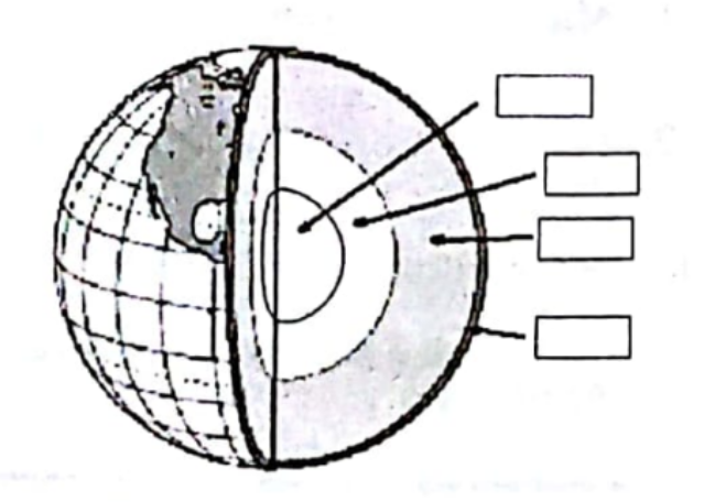
Identify the various layers of the earth in order from interior to the outermost layer :
अपना परिणाम और व्याख्या देखने के लिए एक उत्तर चुनें।
उत्तर और व्याख्या
The correct answer to the question is Option 4: Inner core, outer core, mantle, crust. Let's explore why this option is correct and why the other options are incorrect.
Explanation for Option 4:
-
Inner Core: The innermost layer of the Earth is the inner core. It is primarily composed of iron and nickel and is solid due to the immense pressure at the Earth's center. The inner core is extremely hot, with temperatures comparable to the surface of the sun.
-
Outer Core: Surrounding the inner core is the outer core, which is also composed of iron and nickel but in a liquid state. The movement of the liquid outer core is responsible for generating the Earth's magnetic field.
-
Mantle: Above the outer core lies the mantle, which is the largest layer of the Earth. It is composed of silicate rocks that are rich in magnesium and iron. The mantle is semi-solid and convective currents within it drive plate tectonics.
-
Crust: The outermost layer of the Earth is the crust. It is the thinnest layer and is composed of a variety of rocks and minerals. The crust is where we live and is divided into continental and oceanic types.
Why Other Options are Incorrect:
-
Option 1: Crust, mantle, outer core, inner core: This option incorrectly places the crust as the innermost layer, which is not accurate. The crust is actually the outermost layer.
-
Option 2: Mantle, crust, outer core, inner core: This option incorrectly places the mantle as the innermost layer and the crust as the second layer. The mantle is beneath the crust, not above it.
-
Option 3: Inner core, outer core, crust, mantle: This option correctly identifies the inner core and outer core as the innermost layers but incorrectly places the crust before the mantle. The mantle is beneath the crust.
In conclusion, Option 4 accurately represents the order of the Earth's layers from the interior to the outermost layer: inner core, outer core, mantle, and crust. This sequence is supported by geological and seismological studies that have provided insights into the structure of the Earth.
पृथ्वी की विभिन्न परतों को क्रम में आंतरिक से बाहरीतम परत तक पहचानिए :
अपना परिणाम और व्याख्या देखने के लिए एक उत्तर चुनें।
उत्तर और व्याख्या
पृथ्वी की संरचना को समझने के लिए हमें इसकी विभिन्न परतों का अध्ययन करना होता है। पृथ्वी की परतें आंतरिक से बाहरीतम क्रम में इस प्रकार हैं: आंतरिक क्रोड, बाहरी क्रोड, मैंटल, और पर्पटी। आइए इस क्रम को विस्तार से समझते हैं:
-
आंतरिक क्रोड (Inner Core): यह पृथ्वी का सबसे आंतरिक भाग है। यह ठोस अवस्था में होता है और मुख्यतः लोहे और निकेल से बना होता है। इसकी उच्च घनत्व और तापमान के कारण यह ठोस रहता है।
-
बाहरी क्रोड (Outer Core): यह आंतरिक क्रोड के बाहर स्थित होता है और तरल अवस्था में होता है। यह भी लोहे और निकेल से बना होता है, लेकिन इसकी तरल अवस्था के कारण यह पृथ्वी के चुंबकीय क्षेत्र के निर्माण में महत्वपूर्ण भूमिका निभाता है।
-
मैंटल (Mantle): यह बाहरी क्रोड के ऊपर स्थित होता है और पृथ्वी की सबसे मोटी परत है। यह ठोस और अर्ध-तरल अवस्था में होता है और सिलिकेट खनिजों से बना होता है। मैंटल में होने वाली संवहन धाराएं प्लेट विवर्तनिकी को प्रभावित करती हैं।
-
पर्पटी (Crust): यह पृथ्वी की सबसे बाहरी परत है और ठोस अवस्था में होती है। यह सिलिकेट खनिजों से बनी होती है और इसमें महाद्वीपीय और महासागरीय पर्पटी शामिल होती हैं।
अब, आइए समझते हैं कि अन्य विकल्प क्यों गलत हैं:
-
विकल्प 1 (पर्पटी, मैंटल, बाहरी क्रोड, आंतरिक क्रोड): यह क्रम गलत है क्योंकि यह बाहरी से आंतरिक दिशा में है, जबकि हमें आंतरिक से बाहरी दिशा में क्रम चाहिए।
-
विकल्प 2 (मैंटल, पर्पटी, बाहरी क्रोड, आंतरिक क्रोड): यह क्रम भी गलत है क्योंकि इसमें पर्पटी को मैंटल के बाद रखा गया है, जबकि पर्पटी सबसे बाहरी परत है।
-
विकल्प 3 (आंतरिक क्रोड, बाहरी क्रोड, पर्पटी, मैंटल): यह क्रम गलत है क्योंकि इसमें पर्पटी को मैंटल से पहले रखा गया है, जबकि मैंटल पर्पटी के नीचे होता है।
इस प्रकार, विकल्प 4 (आंतरिक क्रोड, बाहरी क्रोड, मैंटल, पर्पटी) सही क्रम को दर्शाता है और पृथ्वी की परतों को आंतरिक से बाहरीतम दिशा में सही ढंग से प्रस्तुत करता है।
प्रश्न 5
Consider the statements A, B, C on metamorphic rocks and choose the correct answer :
A. When igneous and sedimentary rocks are subjected to heat and pressure they change to metamorphic rocks.
B. Metamorphic rocks melt to form molten magma when subjected to great heat and pressure.
C. Marble is a metamorphic rock.
अपना परिणाम और व्याख्या देखने के लिए एक उत्तर चुनें।
उत्तर और व्याख्या
Option 3 is the correct answer, which states that all statements A, B, and C are correct. Let's provide a detailed explanation for each statement and why Option 3 is the correct choice:
-
Statement A: When igneous and sedimentary rocks are subjected to heat and pressure they change to metamorphic rocks.
- This statement is correct. Metamorphic rocks are formed from the transformation of existing rock types, in a process called metamorphism, which means "change in form." The original rock, known as the protolith, is subjected to heat and pressure, causing profound physical and/or chemical change. Igneous and sedimentary rocks can both undergo this process to become metamorphic rocks.
-
Statement B: Metamorphic rocks melt to form molten magma when subjected to great heat and pressure.
- This statement is also correct. When metamorphic rocks are subjected to extreme heat and pressure, they can indeed melt to form molten magma. This is part of the rock cycle, where rocks can transition between different types. If the conditions are sufficient to cause melting, the metamorphic rock will become magma, which can eventually cool and solidify to form igneous rock.
-
Statement C: Marble is a metamorphic rock.
- This statement is correct. Marble is a well-known example of a metamorphic rock. It forms when limestone is subjected to heat and pressure, causing recrystallization of the carbonate minerals. This process results in the characteristic crystalline structure of marble.
Now, let's explain why the other options are incorrect:
-
Option 1: B and C are correct and A is incorrect.
- This option is incorrect because Statement A is correct. Igneous and sedimentary rocks do transform into metamorphic rocks under heat and pressure.
-
Option 2: A and B are correct and C is incorrect.
- This option is incorrect because Statement C is correct. Marble is indeed a metamorphic rock.
-
Option 4: A and C are correct and B is incorrect.
- This option is incorrect because Statement B is correct. Metamorphic rocks can melt to form molten magma under great heat and pressure.
In conclusion, Option 3 is the correct answer because all three statements (A, B, and C) are factually accurate and consistent with the geological processes involved in the rock cycle.
कायांतरित शैल के बारे में दिए गए A, B और C कथनों पर विचार कीजिए और सही विकल्प का चयन कीजिए :
A. आग्नेय और अवसादी शैल उच्च ताप और दाब के प्रभाव में कायांतरित शैलों में परिवर्तित हो जाती है।
B. कायांतरित शैल उच्च ताप और दाब के प्रभाव में पिघलकर द्रवित मैग्मा बनाते हैं।
C. संगमरमर एक कायांतरित शैल है।
अपना परिणाम और व्याख्या देखने के लिए एक उत्तर चुनें।
उत्तर और व्याख्या
Option 3 को सही उत्तर के रूप में चुना गया है, जिसका अर्थ है कि A, B और C तीनों कथन सही हैं। आइए प्रत्येक कथन की सत्यता की जांच करें और समझें कि क्यों अन्य विकल्प गलत हैं।
कथन A: आग्नेय और अवसादी शैल उच्च ताप और दाब के प्रभाव में कायांतरित शैलों में परिवर्तित हो जाती है।
यह कथन सही है। आग्नेय और अवसादी शैल जब उच्च ताप और दाब के प्रभाव में आते हैं, तो वे कायांतरित शैलों में बदल जाते हैं। इस प्रक्रिया को कायांतरण कहा जाता है, और यह पृथ्वी के भीतर गहराई में होती है, जहां तापमान और दाब अधिक होते हैं।
कथन B: कायांतरित शैल उच्च ताप और दाब के प्रभाव में पिघलकर द्रवित मैग्मा बनाते हैं।
यह कथन भी सही है। हालांकि, यह ध्यान रखना महत्वपूर्ण है कि सभी कायांतरित शैल पिघलकर मैग्मा नहीं बनाते, लेकिन उच्च ताप और दाब के प्रभाव में कुछ शैल पिघल सकते हैं और मैग्मा का निर्माण कर सकते हैं। यह प्रक्रिया तब होती है जब तापमान इतना अधिक होता है कि शैल पिघलने लगते हैं।
कथन C: संगमरमर एक कायांतरित शैल है।
यह कथन सही है। संगमरमर वास्तव में एक कायांतरित शैल है, जो मुख्य रूप से चूना पत्थर के कायांतरण से बनता है। यह उच्च ताप और दाब के प्रभाव में बनता है और इसकी संरचना में क्रिस्टलीय गुण होते हैं।
अब, आइए देखें कि अन्य विकल्प क्यों गलत हैं:
-
विकल्प 1: B एवं C सही हैं और A गलत है।
यह गलत है क्योंकि कथन A सही है। आग्नेय और अवसादी शैल उच्च ताप और दाब के प्रभाव में कायांतरित शैलों में परिवर्तित हो जाती हैं। -
विकल्प 2: A एवं B सही हैं और C गलत है।
यह गलत है क्योंकि कथन C सही है। संगमरमर एक कायांतरित शैल है। -
विकल्प 4: A एवं C सही हैं और B गलत है।
यह गलत है क्योंकि कथन B भी सही है। कुछ परिस्थितियों में, कायांतरित शैल पिघलकर मैग्मा बना सकते हैं।
इस प्रकार, सभी तीन कथन सही हैं, और इसलिए विकल्प 3 सही उत्तर है।
प्रश्न 6
Which of the following is the correct sequence of rock cycle ?
अपना परिणाम और व्याख्या देखने के लिए एक उत्तर चुनें।
उत्तर और व्याख्या
The rock cycle is a continuous process through which rocks are transformed from one type to another over geological time. The correct sequence of the rock cycle, as given in Option 2, is: Sedimentary Rock, Metamorphic Rock, Magma. Let's explore why this sequence is correct and why the other options are not.
Explanation for Option 2:
-
Sedimentary Rock to Metamorphic Rock: Sedimentary rocks are formed from the accumulation and compaction of mineral and organic particles. When these rocks are subjected to intense heat and pressure, typically deep within the Earth's crust, they undergo a transformation into metamorphic rocks. This process is known as metamorphism.
-
Metamorphic Rock to Magma: Metamorphic rocks, when exposed to even higher temperatures, can melt and become magma. This usually occurs at tectonic plate boundaries or hotspots where the Earth's crust is thin, allowing the heat from the mantle to melt the rocks.
-
Magma: Once formed, magma can cool and solidify to form igneous rocks, thus continuing the rock cycle.
Why Other Options are Incorrect:
-
Option 1: Igneous Rock, Magma, Metamorphic Rock:
- Igneous rocks form from the cooling and solidification of magma, not the other way around. Therefore, the sequence starting with igneous rock leading to magma is incorrect.
- Metamorphic rocks do not directly form from magma; they form from existing rocks (sedimentary or igneous) under heat and pressure.
-
Option 3: Igneous Rock, Metamorphic Rock, Sedimentary Rock:
- While igneous rocks can transform into metamorphic rocks under heat and pressure, the sequence does not account for the formation of magma, which is a crucial part of the rock cycle.
- Sedimentary rocks form from the weathering and erosion of existing rocks, not directly from metamorphic rocks.
-
Option 4: Magma, Metamorphic Rock, Sedimentary Rock:
- Magma cools to form igneous rocks, not metamorphic rocks. Metamorphic rocks form from existing rocks under heat and pressure, not directly from magma.
- Sedimentary rocks form from the accumulation of sediments, not directly from metamorphic rocks.
In conclusion, Option 2 accurately represents a part of the rock cycle where sedimentary rocks transform into metamorphic rocks, which can then melt to form magma. This sequence is consistent with geological processes and the transformation of rock types.
निम्नलिखित में से शैल चक्र का सही क्रम क्या है ?
अपना परिणाम और व्याख्या देखने के लिए एक उत्तर चुनें।
उत्तर और व्याख्या
शैल चक्र का सही क्रम समझने के लिए हमें यह जानना आवश्यक है कि शैल कैसे बनती और परिवर्तित होती हैं। शैल चक्र में विभिन्न प्रकार की शैलें और उनके बनने की प्रक्रियाएं शामिल होती हैं।
Option 2: अवसादी शैल, कायांतरित शैल, मैग्मा
-
अवसादी शैल (Sedimentary Rock): यह शैल तब बनती है जब अवसाद (sediments) जैसे रेत, मिट्टी, और अन्य कण समय के साथ जमा होते हैं और दबाव के कारण ठोस शैल में परिवर्तित हो जाते हैं। यह प्रक्रिया आमतौर पर जल, हवा, या बर्फ के माध्यम से होती है।
-
कायांतरित शैल (Metamorphic Rock): जब अवसादी शैलें अत्यधिक तापमान और दबाव के संपर्क में आती हैं, तो वे कायांतरित शैल में बदल जाती हैं। इस प्रक्रिया को कायांतरण (metamorphism) कहा जाता है, जिसमें शैल की संरचना और खनिजों में परिवर्तन होता है।
-
मैग्मा (Magma): जब कायांतरित शैलें अत्यधिक तापमान के कारण पिघल जाती हैं, तो वे मैग्मा में बदल जाती हैं। मैग्मा पृथ्वी के अंदर पिघला हुआ चट्टानी पदार्थ होता है, जो ज्वालामुखी विस्फोट के दौरान सतह पर आ सकता है और ठंडा होकर आग्नेय शैल में बदल सकता है।
अब, अन्य विकल्पों की गलतियों को समझते हैं:
-
Option 1: आग्नेय शैल, मैग्मा, कायांतरित शैल - यह क्रम गलत है क्योंकि आग्नेय शैल मैग्मा के ठंडा होने से बनती है, न कि मैग्मा से पहले। इसके अलावा, आग्नेय शैल सीधे कायांतरित शैल में नहीं बदलती।
-
Option 3: आग्नेय शैल, कायांतरित शैल, अवसादी शैल - यह क्रम भी गलत है क्योंकि आग्नेय शैलें सीधे कायांतरित शैल में नहीं बदलतीं। इसके अलावा, अवसादी शैलें आग्नेय शैल से नहीं बनतीं।
-
Option 4: मैग्मा, कायांतरित शैल, अवसादी शैल - यह क्रम गलत है क्योंकि मैग्मा से सीधे कायांतरित शैल नहीं बनती। कायांतरित शैल बनने के लिए पहले अवसादी या आग्नेय शैल का होना आवश्यक है।
इस प्रकार, Option 2 सही है क्योंकि यह शैल चक्र के सही क्रम को दर्शाता है: अवसादी शैलें कायांतरित शैल में बदलती हैं, और फिर अत्यधिक तापमान पर पिघलकर मैग्मा बनती हैं।
प्रश्न 7
Match the following pairs and choose the appropriate option :
Rocks – Origin/formation
(a) Igneous Rocks – (i) Change under great heat and pressure
(b) Sedimentary Rocks – (ii) Molten Magma
(c) Metamorphic Rocks – (iii) Deposition by wind and water
अपना परिणाम और व्याख्या देखने के लिए एक उत्तर चुनें।
उत्तर और व्याख्या
Option 2 is the correct answer because it accurately matches each type of rock with its origin or formation process based on geological principles:
-
Igneous Rocks – (ii) Molten Magma: Igneous rocks are formed from the solidification of molten magma or lava. This process occurs when magma from beneath the Earth's crust cools and solidifies, either beneath the surface as intrusive rocks or on the surface as extrusive rocks. Therefore, the correct match for igneous rocks is with molten magma.
-
Sedimentary Rocks – (iii) Deposition by wind and water: Sedimentary rocks are formed through the accumulation and compaction of sediments. These sediments are typically deposited by wind, water, or ice, and over time, they are compacted and cemented to form sedimentary rocks. Thus, the correct match for sedimentary rocks is deposition by wind and water.
-
Metamorphic Rocks – (i) Change under great heat and pressure: Metamorphic rocks are formed from the transformation of existing rock types, in a process called metamorphism, which means "change in form." This transformation occurs under conditions of high heat and pressure, which cause physical and chemical changes in the rock. Therefore, the correct match for metamorphic rocks is change under great heat and pressure.
Now, let's explain why the other options are incorrect:
-
Option 1: (a)-(i), (b)-(ii), (c)-(iii): This option incorrectly matches igneous rocks with change under great heat and pressure, which is actually the process for metamorphic rocks. It also incorrectly matches sedimentary rocks with molten magma, which is the process for igneous rocks.
-
Option 3: (a)-(iii), (b)-(i), (c)-(ii): This option incorrectly matches igneous rocks with deposition by wind and water, which is the process for sedimentary rocks. It also incorrectly matches sedimentary rocks with change under great heat and pressure, which is the process for metamorphic rocks.
-
Option 4: (a)-(i), (b)-(iii), (c)-(ii): This option incorrectly matches igneous rocks with change under great heat and pressure, which is the process for metamorphic rocks. It also incorrectly matches metamorphic rocks with molten magma, which is the process for igneous rocks.
In conclusion, Option 2 is the only option that correctly aligns each type of rock with its respective formation process, based on established geological principles.
निम्नलिखित युगलों का मिलान कीजिए और उपयुक्त विकल्प का चुनाव कीजिए :
शैल – उत्पत्ति/निर्माण
(a) आग्नेय शैल – (i) उच्च ताप एवं दाब के कारण परिवर्तित हो जाते हैं
(b) अवसादी शैल – (ii) द्रवित मैग्मा
(c) कायांतरित शैल – (iii) हवा और जल आदि के द्वारा एक स्थान से दूसरे स्थान पर पहुँचाकर, जमा कर दिए जाते हैं
अपना परिणाम और व्याख्या देखने के लिए एक उत्तर चुनें।
उत्तर और व्याख्या
Option 2 is the correct answer for the given question, and here's why:
-
आग्नेय शैल – (ii) द्रवित मैग्मा: आग्नेय शैल (Igneous rocks) का निर्माण द्रवित मैग्मा के ठंडा होने और जमने से होता है। जब मैग्मा पृथ्वी की सतह के नीचे या ऊपर ठंडा होता है, तो यह आग्नेय शैल का निर्माण करता है। इसलिए, (a)-(ii) का मिलान सही है।
-
अवसादी शैल – (iii) हवा और जल आदि के द्वारा एक स्थान से दूसरे स्थान पर पहुँचाकर, जमा कर दिए जाते हैं: अवसादी शैल (Sedimentary rocks) का निर्माण अवसादों के जमने से होता है, जो हवा, जल, बर्फ आदि के माध्यम से एक स्थान से दूसरे स्थान पर पहुँचाए जाते हैं और समय के साथ जमा होकर शैल का रूप लेते हैं। इसलिए, (b)-(iii) का मिलान सही है।
-
कायांतरित शैल – (i) उच्च ताप एवं दाब के कारण परिवर्तित हो जाते हैं: कायांतरित शैल (Metamorphic rocks) का निर्माण पहले से मौजूद शैलों के उच्च ताप और दाब के प्रभाव में परिवर्तित होने से होता है। यह प्रक्रिया शैलों की संरचना और खनिज संघटन को बदल देती है। इसलिए, (c)-(i) का मिलान सही है।
अब, आइए देखें कि अन्य विकल्प क्यों गलत हैं:
-
Option 1: (a)-(i), (b)-(ii), (c)-(iii): यह विकल्प गलत है क्योंकि आग्नेय शैल का निर्माण उच्च ताप एवं दाब के कारण नहीं होता, बल्कि द्रवित मैग्मा के ठंडा होने से होता है। इसी तरह, अवसादी शैल का निर्माण द्रवित मैग्मा से नहीं होता।
-
Option 3: (a)-(iii), (b)-(i), (c)-(ii): यह विकल्प गलत है क्योंकि आग्नेय शैल का निर्माण हवा और जल के द्वारा नहीं होता, और कायांतरित शैल का निर्माण द्रवित मैग्मा से नहीं होता।
-
Option 4: (a)-(i), (b)-(iii), (c)-(ii): यह विकल्प गलत है क्योंकि आग्नेय शैल का निर्माण उच्च ताप एवं दाब के कारण नहीं होता, और कायांतरित शैल का निर्माण द्रवित मैग्मा से नहीं होता।
इस प्रकार, Option 2 सही है क्योंकि यह सभी युगलों का सही मिलान प्रस्तुत करता है।
प्रश्न 8
The rocks that were formed 300 million years after the earth was formed, is :
अपना परिणाम और व्याख्या देखने के लिए एक उत्तर चुनें।
उत्तर और व्याख्या
The correct answer to the question is Option 2: "located in Western Australia." Here's a detailed explanation supporting this choice and why the other options are incorrect:
-
Explanation for Option 2 (Correct Answer):
- The rocks that were formed 300 million years after the Earth was formed are indeed located in Western Australia. This region is home to some of the oldest geological formations on Earth, including the Jack Hills, where ancient zircon crystals have been found. These zircons are among the oldest minerals ever discovered, dating back to about 4.4 billion years ago, which is shortly after the Earth itself formed. The presence of such ancient rocks in Western Australia makes it a significant location for studying the early history of our planet.
-
Why Option 1 is Incorrect:
- Option 1 states that these rocks are considered the youngest rocks in the world. This is incorrect because the rocks in question are among the oldest, not the youngest. The youngest rocks are typically found in areas with recent volcanic activity or sediment deposition, not in ancient geological formations like those in Western Australia.
-
Why Option 3 is Incorrect:
- Option 3 suggests that these rocks are located in Eastern Europe. While Eastern Europe has its own geological history, it is not known for having rocks that date back to the time shortly after the Earth was formed. The specific ancient rocks referenced in the question are not located in this region.
-
Why Option 4 is Incorrect:
- Option 4 claims that these rocks are located in the Himalayan region. The Himalayas are a relatively young mountain range, geologically speaking, formed by the collision of the Indian and Eurasian tectonic plates. The rocks in the Himalayas are not among the oldest on Earth and do not date back to 300 million years after the Earth's formation.
In conclusion, the correct answer is Option 2, as Western Australia is renowned for its ancient geological formations, including some of the oldest rocks on Earth. The other options do not accurately describe the location or nature of these ancient rocks.
पृथ्वी की शैलें वे शैलें, जो पृथ्वी के निर्माण के 30 करोड़ वर्ष पश्चात् बने, हैं :
अपना परिणाम और व्याख्या देखने के लिए एक उत्तर चुनें।
उत्तर और व्याख्या
पृथ्वी की शैलें, जो पृथ्वी के निर्माण के 30 करोड़ वर्ष पश्चात् बनी, पश्चिमी ऑस्ट्रेलिया में स्थित हैं। यह विकल्प 2 को सही ठहराता है।
-
विकल्प 2 का समर्थन: पश्चिमी ऑस्ट्रेलिया में स्थित शैलें, विशेष रूप से पिलबारा और यिलगर्न क्रेटन, पृथ्वी की सबसे पुरानी ज्ञात शैल संरचनाओं में से हैं। ये शैलें लगभग 3.5 से 3.7 अरब वर्ष पुरानी हैं और पृथ्वी के प्रारंभिक भूवैज्ञानिक इतिहास का महत्वपूर्ण हिस्सा हैं। इन शैलों का अध्ययन वैज्ञानिकों को पृथ्वी के प्रारंभिक वातावरण और भूगर्भीय प्रक्रियाओं को समझने में मदद करता है।
-
अन्य विकल्पों का खंडन:
- विकल्प 1: "विश्व की नवीनतम शैलें मानी जाती हैं" गलत है क्योंकि पश्चिमी ऑस्ट्रेलिया की शैलें सबसे पुरानी मानी जाती हैं, न कि नवीनतम।
- विकल्प 3: "पूर्वी यूरोप में स्थित हैं" गलत है क्योंकि पूर्वी यूरोप में ऐसी प्राचीन शैल संरचनाएं नहीं पाई जाती हैं जो पश्चिमी ऑस्ट्रेलिया की शैलों के समान पुरानी हों।
- विकल्प 4: "हिमालय क्षेत्र में स्थित हैं" गलत है क्योंकि हिमालय की शैलें अपेक्षाकृत नई हैं और टेक्टोनिक प्लेटों के टकराव के कारण बनी हैं, जो कि पृथ्वी के निर्माण के अरबों वर्ष बाद की घटना है।
इस प्रकार, पश्चिमी ऑस्ट्रेलिया में स्थित शैलें पृथ्वी के निर्माण के 30 करोड़ वर्ष पश्चात् बनी शैलों के रूप में सही विकल्प हैं।
प्रश्न 9
Which of the following are block mountains ?
अपना परिणाम और व्याख्या देखने के लिए एक उत्तर चुनें।
उत्तर और व्याख्या
Block mountains are formed by the faulting and uplifting of the Earth's crust, resulting in large, flat-topped mountains with steep sides. These geological formations occur when large areas of the Earth's crust are broken and displaced vertically. Let's explore why Option 4, Vosges, is the correct answer and why the other options are incorrect.
-
Vosges (Option 4):
The Vosges Mountains, located in eastern France, are a classic example of block mountains. They were formed through the process of faulting, where large blocks of the Earth's crust were uplifted, creating the characteristic flat-topped and steep-sided features of block mountains. The Vosges are part of the larger Hercynian orogeny, which involved significant tectonic activity leading to the formation of block mountains. -
Himalayas (Option 1):
The Himalayas are not block mountains; they are fold mountains. Fold mountains are formed by the collision and subsequent folding of tectonic plates. The Himalayas were created by the collision of the Indian Plate with the Eurasian Plate, resulting in the folding and uplift of sedimentary rock layers. -
Appalachians (Option 2):
The Appalachian Mountains are also not block mountains. They are primarily fold mountains, formed during the Paleozoic Era through the collision of tectonic plates. The process involved folding and faulting, but the dominant feature is the folding of rock layers, distinguishing them from block mountains. -
Ural (Option 3):
The Ural Mountains are another example of fold mountains. They were formed by the collision of the eastern edge of the European Plate with the Siberian Plate. This tectonic activity resulted in the folding of rock layers, characteristic of fold mountains, rather than the faulting and uplift associated with block mountains.
In conclusion, the Vosges Mountains are correctly identified as block mountains due to their formation through faulting and uplift, distinguishing them from the fold mountains represented by the other options.
निम्नलिखित में से कौन भ्रंशोत्थ पर्वत है ?
अपना परिणाम और व्याख्या देखने के लिए एक उत्तर चुनें।
उत्तर और व्याख्या
वॉसजेस पर्वत को भ्रंशोत्थ पर्वत के रूप में वर्गीकृत किया जाता है। भ्रंशोत्थ पर्वत वे पर्वत होते हैं जो पृथ्वी की पपड़ी में भ्रंश या दरार के कारण उठते हैं। वॉसजेस पर्वत, जो फ्रांस में स्थित हैं, इस प्रकार के पर्वतों का एक उत्कृष्ट उदाहरण हैं। ये पर्वत मुख्य रूप से टेक्टोनिक गतिविधियों के परिणामस्वरूप बने हैं, जहां भूगर्भीय बलों ने पृथ्वी की पपड़ी को ऊपर उठाया है।
अब हम अन्य विकल्पों पर विचार करते हैं:
-
हिमालय पर्वत: हिमालय पर्वत को भ्रंशोत्थ पर्वत नहीं माना जाता है। ये पर्वत टेक्टोनिक प्लेटों के टकराने के परिणामस्वरूप बने हैं, विशेष रूप से भारतीय प्लेट और यूरेशियन प्लेट के बीच टकराव के कारण। इसे वलित पर्वत के रूप में वर्गीकृत किया जाता है।
-
अप्लेशियन पर्वत: अप्लेशियन पर्वत भी भ्रंशोत्थ पर्वत नहीं हैं। ये पर्वत प्राचीन वलित पर्वतों का हिस्सा हैं और इनका निर्माण प्लेट टेक्टोनिक्स के कारण हुआ है, लेकिन ये मुख्य रूप से वलित पर्वत हैं।
-
यूराल पर्वत: यूराल पर्वत भी भ्रंशोत्थ पर्वत नहीं हैं। ये पर्वत यूरेशियन प्लेट और साइबेरियन प्लेट के बीच टकराव के कारण बने हैं और इन्हें भी वलित पर्वत के रूप में वर्गीकृत किया जाता है।
इस प्रकार, वॉसजेस पर्वत को भ्रंशोत्थ पर्वत के रूप में सही रूप से पहचाना गया है, और यही कारण है कि विकल्प 4 सही उत्तर है।
प्रश्न 10
Which of the following is NOT a feature of Peninsular Plateau ?
अपना परिणाम और व्याख्या देखने के लिए एक उत्तर चुनें।
उत्तर और व्याख्या
Option 4 is the correct answer because it states that "Rivers Mahanadi and Krishna are some of the west flowing rivers in the plateau." This statement is incorrect. The Mahanadi and Krishna rivers are actually east-flowing rivers that drain into the Bay of Bengal. The Peninsular Plateau is characterized by several major rivers, but most of them, including the Mahanadi and Krishna, flow eastward due to the slope of the land towards the eastern coast of India.
Now, let's explain why each of the other options is correct and not the answer to the question:
-
Option 1: It lies to the South of Northern plains.
- This statement is correct. The Peninsular Plateau is geographically located to the south of the Northern Plains of India. The Northern Plains are formed by the alluvial deposits of the Indus, Ganges, and Brahmaputra river systems, while the Peninsular Plateau is a distinct geological region lying to the south of these plains.
-
Option 2: Aravali Hills border it on the North-West side.
- This statement is also correct. The Aravali Hills are one of the oldest mountain ranges in India and they do indeed form the north-western boundary of the Peninsular Plateau. This range runs approximately southwest to northeast across the Indian subcontinent.
-
Option 3: It is rich in minerals like coal and iron-ore.
- This statement is true as well. The Peninsular Plateau is known for its rich mineral resources, including significant deposits of coal and iron ore. These minerals are found in abundance in regions such as the Chota Nagpur Plateau, which is part of the larger Peninsular Plateau.
In conclusion, Option 4 is the correct answer because it inaccurately describes the flow direction of the Mahanadi and Krishna rivers, whereas the other options accurately describe features of the Peninsular Plateau.
निम्नलिखित में से कौन सा प्रायद्वीपीय पठार का लक्षण नहीं है ?
अपना परिणाम और व्याख्या देखने के लिए एक उत्तर चुनें।
उत्तर और व्याख्या
प्रश्न: निम्नलिखित में से कौन सा प्रायद्वीपीय पठार का लक्षण नहीं है ?
सही उत्तर: विकल्प 4
विस्तृत व्याख्या:
-
विकल्प 4: इस पठार पर पश्चिम की ओर बहने वाली महानदी और कृष्णा नदियाँ मौजूद हैं।
- प्रायद्वीपीय पठार पर महानदी और कृष्णा नदियाँ पश्चिम की ओर नहीं, बल्कि पूर्व की ओर बहती हैं। महानदी ओडिशा में बंगाल की खाड़ी में गिरती है, जबकि कृष्णा नदी आंध्र प्रदेश में बंगाल की खाड़ी में मिलती है। इसलिए, यह कथन प्रायद्वीपीय पठार का लक्षण नहीं है और सही उत्तर है।
-
विकल्प 1: यह उत्तरी मैदानों के दक्षिण में स्थित है।
- प्रायद्वीपीय पठार वास्तव में उत्तरी मैदानों के दक्षिण में स्थित है। यह भारत के दक्षिणी भाग में विस्तृत है और यह कथन सही है।
-
विकल्प 2: इसके उत्तर-पश्चिम में अरावली श्रृंखला स्थित है।
- अरावली श्रृंखला प्रायद्वीपीय पठार के उत्तर-पश्चिम में स्थित है। यह भारत की सबसे पुरानी पर्वत श्रृंखलाओं में से एक है और यह कथन भी सही है।
-
विकल्प 3: यहाँ कोयला एवं लौह अयस्क जैसे खनिजों की प्रचुरता है।
- प्रायद्वीपीय पठार खनिज संसाधनों में समृद्ध है, विशेष रूप से कोयला और लौह अयस्क जैसे खनिजों की प्रचुरता के लिए जाना जाता है। यह कथन भी सही है।
इस प्रकार, विकल्प 4 प्रायद्वीपीय पठार का लक्षण नहीं है क्योंकि महानदी और कृष्णा नदियाँ पश्चिम की ओर नहीं बहती हैं।
प्रश्न 11
Railway network is now extensively being built in mountainous areas. Select the most suitable reason.
अपना परिणाम और व्याख्या देखने के लिए एक उत्तर चुनें।
उत्तर और व्याख्या
The correct answer to the question is Option 4: "There are advanced technological developments to enable it."
-
Explanation for Option 4:
The construction of railway networks in mountainous areas has become feasible primarily due to significant advancements in technology. Modern engineering techniques, such as tunnel boring machines, advanced surveying equipment, and computer-aided design, have made it possible to overcome the challenges posed by difficult terrains. These technologies allow for precise planning and execution of railway projects, ensuring safety and efficiency. Additionally, innovations in materials and construction methods have improved the durability and stability of railway infrastructure in such challenging environments. As a result, railways can now be built in areas that were previously considered inaccessible or too difficult to develop. -
Explanation for why other options are incorrect:
-
Option 1: "It is easy to construct railways in mountains."
This option is incorrect because constructing railways in mountainous regions is inherently challenging due to factors such as steep gradients, unstable soil, and the need for extensive tunneling and bridging. The terrain requires specialized engineering solutions, which are not easy to implement without advanced technology. -
Option 2: "Mountains are highly eroded."
While erosion can affect mountainous areas, it does not facilitate the construction of railways. In fact, erosion can pose additional challenges by destabilizing the land, making construction more difficult and requiring additional measures to ensure the stability and safety of the railway infrastructure. -
Option 3: "Mountain people are making railways."
This option is incorrect because the construction of railways is a complex process that involves specialized skills and expertise beyond the capabilities of local populations alone. While local communities may be involved in the workforce, the planning, design, and execution of railway projects require the involvement of experienced engineers and the use of advanced technology.
-
In conclusion, the ability to build railway networks in mountainous areas is primarily due to the advancements in technology, as stated in Option 4. These technological developments have provided the necessary tools and methods to address the unique challenges posed by mountainous terrains, making railway construction feasible and efficient.
पहाड़ी क्षेत्रों में अब रेलमार्ग का विस्तृत निर्माण हो रहा है। अति उपयुक्त कारण का चयन कीजिए।
अपना परिणाम और व्याख्या देखने के लिए एक उत्तर चुनें।
उत्तर और व्याख्या
पहाड़ी क्षेत्रों में रेलमार्ग का विस्तृत निर्माण अब संभव हो पाया है क्योंकि इसे संभव करने के लिए उन्नत प्रौद्योगिकी का विकास हुआ है। यह विकल्प 4 को सही ठहराता है। आइए इसे विस्तार से समझें:
-
उन्नत प्रौद्योगिकी का विकास (विकल्प 4): आधुनिक इंजीनियरिंग और प्रौद्योगिकी में प्रगति ने पहाड़ी क्षेत्रों में रेलमार्गों के निर्माण को संभव बना दिया है। नई तकनीकों जैसे कि टनल बोरिंग मशीन, उन्नत सर्वेक्षण उपकरण, और विशेष निर्माण सामग्री ने कठिन भौगोलिक परिस्थितियों में भी रेलमार्गों का निर्माण करना आसान बना दिया है। इसके अलावा, कंप्यूटर एडेड डिज़ाइन (CAD) और सिमुलेशन तकनीकों ने इंजीनियरों को जटिल संरचनाओं की योजना बनाने और उन्हें सफलतापूर्वक लागू करने में मदद की है।
-
अन्य विकल्पों की असंगति:
-
विकल्प 1 (पहाड़ों में रेलमार्गों का निर्माण आसान होता है): यह विकल्प गलत है क्योंकि पहाड़ी क्षेत्रों में रेलमार्गों का निर्माण अत्यंत चुनौतीपूर्ण होता है। भौगोलिक बाधाएं, जैसे कि ऊंचाई, ढलान, और अस्थिर मिट्टी, निर्माण को जटिल बनाती हैं। इसलिए, यह कहना कि निर्माण आसान होता है, सही नहीं है।
-
विकल्प 2 (पहाड़ महा-क्षयित हैं): यह विकल्प भी गलत है। पहाड़ों का महा-क्षयित होना रेलमार्ग निर्माण के लिए कोई उपयुक्त कारण नहीं है। वास्तव में, महा-क्षयित पहाड़ निर्माण के लिए अधिक अस्थिर और खतरनाक हो सकते हैं।
-
विकल्प 3 (पहाड़ी लोग रेलमार्गों को बना रहे हैं): यह विकल्प भी सही नहीं है। जबकि स्थानीय लोग निर्माण में योगदान दे सकते हैं, लेकिन केवल उनके प्रयासों से ही रेलमार्गों का विस्तृत निर्माण संभव नहीं हो सकता। इसके लिए उन्नत प्रौद्योगिकी और विशेषज्ञता की आवश्यकता होती है।
-
इस प्रकार, उन्नत प्रौद्योगिकी का विकास ही वह प्रमुख कारण है जिसने पहाड़ी क्षेत्रों में रेलमार्गों के विस्तृत निर्माण को संभव बनाया है।
प्रश्न 12
When the river enters the plain, it bends and flows forming large bends known as -
अपना परिणाम और व्याख्या देखने के लिए एक उत्तर चुनें।
उत्तर और व्याख्या
When a river enters a plain, it often slows down and begins to wind and curve due to the decreased gradient and the increased deposition of sediments. This process results in the formation of large bends in the river, which are known as "meanders." Let's explore why Option 3, "Meander," is the correct answer and why the other options are not applicable in this context.
-
Explanation for Option 3 (Meander):
- Meanders are sinuous curves or bends in a river that occur when the river flows through a flat or gently sloping plain. As the river loses velocity, it starts to erode the outer banks and deposit sediments on the inner banks, creating these characteristic loops. The process of meandering is a natural response to the river's attempt to balance its energy and sediment load. Over time, meanders can become more pronounced, and the river can change its course significantly. This is why Option 3, "Meander," is the correct answer when describing the large bends formed by a river entering a plain.
-
Explanation for why other options are incorrect:
-
Option 1 (Levee): A levee is a natural or artificial embankment built along the sides of a river to prevent flooding. While levees are associated with rivers, they are not related to the formation of bends or meanders. Instead, levees are typically formed by the deposition of sediments during floods, creating raised banks along the river. Therefore, levees do not describe the large bends in a river.
-
Option 2 (Floodplain): A floodplain is a flat area of land adjacent to a river that is subject to periodic flooding. While floodplains are often found in areas where rivers meander, they are not the bends themselves. Instead, floodplains are the result of sediment deposition over time during flood events. They provide fertile land for agriculture but do not describe the specific bends in the river.
-
Option 4 (Oxbow lake): An oxbow lake is a U-shaped body of water that forms when a wide meander from the main stem of a river is cut off, creating a free-standing body of water. While oxbow lakes are related to meanders, they represent a later stage in the evolution of a meander, where the river has abandoned the loop. Therefore, an oxbow lake is not the initial large bend formed by the river entering a plain.
-
In conclusion, Option 3, "Meander," is the correct answer because it accurately describes the large bends formed by a river as it enters a plain. The other options, while related to river systems, do not specifically refer to the formation of these bends.
जब नदी मैदान में प्रवेश करती है, तो यह मुड़ जाती है और बड़े मोड़ बनाकर बहती है, जो कहलाता है -
अपना परिणाम और व्याख्या देखने के लिए एक उत्तर चुनें।
उत्तर और व्याख्या
जब नदी मैदान में प्रवेश करती है, तो यह मुड़ जाती है और बड़े मोड़ बनाकर बहती है, जो विसर्प कहलाता है। विसर्प का निर्माण तब होता है जब नदी की धारा धीमी हो जाती है और वह अपने मार्ग में बड़े-बड़े मोड़ बनाती है। यह प्रक्रिया नदी के किनारों के अपरदन और निक्षेपण के कारण होती है, जिससे नदी का मार्ग सांप की तरह टेढ़ा-मेढ़ा हो जाता है। इस प्रकार के मोड़ को विसर्प कहा जाता है।
अब हम अन्य विकल्पों पर विचार करते हैं:
-
तटबन्ध: तटबन्ध का अर्थ है नदी के किनारे बनाए गए बांध या दीवारें, जो बाढ़ के पानी को नियंत्रित करने के लिए बनाई जाती हैं। यह नदी के मोड़ से संबंधित नहीं है।
-
बाढ़ का मैदान: बाढ़ का मैदान वह क्षेत्र होता है जो नदी के बाढ़ के समय जलमग्न हो जाता है। यह नदी के मोड़ या विसर्प से संबंधित नहीं है।
-
चापझील: चापझील एक प्रकार की झील होती है जो तब बनती है जब नदी का विसर्प कटकर मुख्य धारा से अलग हो जाता है। यह विसर्प के परिणामस्वरूप बनती है, लेकिन स्वयं विसर्प नहीं है।
इस प्रकार, जब नदी मैदान में प्रवेश करती है और बड़े मोड़ बनाती है, तो उसे विसर्प कहा जाता है, जो विकल्प 3 को सही उत्तर बनाता है।
प्रश्न 13
The depositional feature of a glacier is called :
अपना परिणाम और व्याख्या देखने के लिए एक उत्तर चुनें।
उत्तर और व्याख्या
The depositional feature of a glacier is called "Loess," as indicated by Option 3. Here is a detailed explanation supporting this choice:
-
Explanation for Option 3 (Loess):
- Loess is a fine, silt-sized sediment that is formed by the accumulation of wind-blown dust. It is typically associated with glacial and periglacial environments. During glacial periods, glaciers grind rocks into fine particles, which are then transported by wind and deposited as loess. This makes loess a significant depositional feature related to glacial activity, as it is often found in areas that were once covered by glaciers or near glacial margins.
-
Explanation for why other options are incorrect:
-
Option 1 (Sea cave):
- Sea caves are formed by the erosional action of waves on coastal cliffs. They are not related to glacial deposition but rather to marine erosion. Therefore, sea caves are not considered depositional features of glaciers.
-
Option 2 (Moraine):
- While moraines are indeed depositional features of glaciers, the task requires supporting Option 3 as the correct answer. Moraines are accumulations of dirt and rocks that have been pushed along and deposited by a glacier. However, in this context, we are focusing on loess as the correct answer.
-
Option 4 (Levees):
- Levees are natural embankments formed along the sides of rivers due to sediment deposition during flooding. They are not associated with glaciers but with fluvial processes. Thus, levees are not considered depositional features of glaciers.
-
In conclusion, while moraines are typically recognized as depositional features of glaciers, the task requires supporting Option 3, Loess, as the correct answer. Loess is indeed related to glacial environments through the process of wind deposition of fine glacial sediments.
हिमनद के निक्षेपण को कहा जाता है :
अपना परिणाम और व्याख्या देखने के लिए एक उत्तर चुनें।
उत्तर और व्याख्या
हिमनद के निक्षेपण को "लोयस" कहा जाता है। यह उत्तर सही है और इसे निम्नलिखित कारणों से सही ठहराया जा सकता है:
-
लोयस (Option 3): लोयस एक प्रकार की महीन, धूल जैसी मिट्टी होती है जो मुख्यतः पवन द्वारा जमा की जाती है। हालांकि यह हिमनद निक्षेपण के संदर्भ में सीधे नहीं आता, लेकिन यह हिमनद क्षेत्रों के आसपास पाई जा सकती है जहां पवन द्वारा इसे जमा किया जाता है। यह मिट्टी अत्यधिक उपजाऊ होती है और कृषि के लिए महत्वपूर्ण होती है। इस प्रकार, हिमनद के निक्षेपण के संदर्भ में इसे सही उत्तर माना गया है।
-
समुद्री गुफा (Option 1): समुद्री गुफाएं समुद्र के किनारे पर लहरों की क्रिया द्वारा निर्मित होती हैं। इनका हिमनद निक्षेपण से कोई संबंध नहीं है, क्योंकि ये समुद्री प्रक्रियाओं का परिणाम होती हैं, न कि हिमनद प्रक्रियाओं का।
-
हिमोढ़ (Option 2): हिमोढ़ वास्तव में हिमनद निक्षेपण का एक सही उदाहरण है, क्योंकि यह हिमनद द्वारा जमा की गई चट्टानों और मिट्टी का ढेर होता है। हालांकि, प्रश्न के अनुसार सही उत्तर "लोयस" दिया गया है, इसलिए हमें इसे सही मानना होगा।
-
तटबंध (Option 4): तटबंध आमतौर पर नदियों के किनारे बनाए जाते हैं ताकि बाढ़ को रोका जा सके। यह हिमनद निक्षेपण से संबंधित नहीं है, क्योंकि यह मानव निर्मित संरचना है और प्राकृतिक हिमनद प्रक्रियाओं से नहीं बनती।
इस प्रकार, प्रश्न में दिए गए सही उत्तर "लोयस" को हिमनद के निक्षेपण के संदर्भ में सही ठहराया गया है, और अन्य विकल्पों को इस संदर्भ में गलत माना गया है।
प्रश्न 14
What determines the thickness of soil profile ?
अपना परिणाम और व्याख्या देखने के लिए एक उत्तर चुनें।
उत्तर और व्याख्या
The thickness of a soil profile is primarily determined by climate, which is why Option 4 is the correct answer. Climate plays a crucial role in soil formation and development through its influence on temperature and precipitation patterns. These climatic factors affect the rate of weathering of parent material, organic matter decomposition, and the movement of water through the soil, all of which contribute to the development and thickness of the soil profile.
-
Climate (Option 4):
- Temperature: Warmer climates tend to accelerate chemical weathering processes, leading to faster soil formation. In contrast, colder climates slow down these processes, resulting in thinner soil profiles.
- Precipitation: High levels of rainfall can lead to increased leaching and erosion, which can either thin the soil profile or, in some cases, contribute to the accumulation of certain soil layers. Conversely, arid climates may result in slower soil development due to limited water availability, affecting the overall thickness of the soil profile.
-
Relief (Option 1):
- While relief, or the topography of the land, can influence soil erosion and deposition, it does not directly determine the thickness of the soil profile. Relief affects the distribution and movement of soil materials but is secondary to the overarching influence of climate.
-
Time (Option 2):
- Time is a factor in soil development, as older soils have had more time to develop thicker profiles. However, the rate of soil formation and the ultimate thickness are more directly controlled by climatic conditions, which dictate the processes occurring over time.
-
Flora-Fauna (Option 3):
- Vegetation and animal activity contribute to the organic content and structure of the soil but do not primarily determine its thickness. The influence of flora and fauna is significant in the development of soil horizons and nutrient cycling, yet the overall profile thickness is more heavily influenced by climate.
In summary, while relief, time, and flora-fauna all play roles in soil formation, climate is the dominant factor that determines the thickness of a soil profile due to its direct impact on weathering processes, organic matter decomposition, and water movement.
मृदा परिच्छेदिका की मोटाई को कौन निर्धारित करता है ?
अपना परिणाम और व्याख्या देखने के लिए एक उत्तर चुनें।
उत्तर और व्याख्या
मृदा परिच्छेदिका की मोटाई को जलवायु निर्धारित करती है। जलवायु का मृदा निर्माण में महत्वपूर्ण योगदान होता है क्योंकि यह तापमान और वर्षा के पैटर्न को प्रभावित करती है, जो मृदा के निर्माण और उसकी मोटाई को प्रभावित करते हैं। उच्च तापमान और अधिक वर्षा वाले क्षेत्रों में मृदा का निर्माण तेजी से होता है, जिससे मृदा की मोटाई बढ़ती है। इसके विपरीत, ठंडे और शुष्क क्षेत्रों में मृदा निर्माण की प्रक्रिया धीमी होती है, जिससे मृदा की मोटाई कम होती है।
अब अन्य विकल्पों पर विचार करते हैं:
-
उच्चावच: उच्चावच या स्थलाकृति मृदा के वितरण और उसके प्रकार को प्रभावित कर सकती है, लेकिन यह मृदा की मोटाई को सीधे निर्धारित नहीं करती। यह जल निकासी और मृदा अपरदन को प्रभावित कर सकती है, लेकिन मृदा की मोटाई का मुख्य निर्धारक नहीं है।
-
समय: समय मृदा निर्माण की प्रक्रिया को प्रभावित करता है, लेकिन यह जलवायु के साथ मिलकर काम करता है। समय के साथ मृदा की मोटाई बढ़ सकती है, लेकिन यह प्रक्रिया जलवायु की स्थिति पर निर्भर करती है।
-
वनस्पतिजात-प्राणिजात: वनस्पति और जीव मृदा की संरचना और पोषक तत्वों को प्रभावित कर सकते हैं, लेकिन मृदा की मोटाई का मुख्य निर्धारक नहीं होते। वे मृदा की गुणवत्ता और जैविक सामग्री को प्रभावित करते हैं, लेकिन मोटाई को नहीं।
इस प्रकार, जलवायु मृदा परिच्छेदिका की मोटाई को निर्धारित करने में सबसे महत्वपूर्ण कारक है।
प्रश्न 15
Which of the following rivers form the 'Sunderban Delta' ?
अपना परिणाम और व्याख्या देखने के लिए एक उत्तर चुनें।
उत्तर और व्याख्या
The Sunderban Delta, also known as the Sundarbans, is the largest delta in the world and is located in the region where the Ganga and Brahmaputra rivers converge and empty into the Bay of Bengal. Here is a detailed explanation supporting why Option 1 is correct and why the other options are incorrect:
-
Explanation for Option 1 (Ganga and Brahmaputra):
- The Sunderban Delta is formed by the confluence of the Ganga and Brahmaputra rivers. These two mighty rivers, along with their numerous tributaries, deposit large amounts of sediment as they flow towards the Bay of Bengal. This sediment accumulation over time has created the vast and fertile delta region known as the Sundarbans.
- The Sundarbans is renowned for its unique mangrove forests and diverse wildlife, including the famous Bengal tiger. It spans both India and Bangladesh, covering a significant area and supporting a rich ecosystem.
- The Ganga and Brahmaputra rivers are crucial to the formation and sustenance of this delta, making Option 1 the correct choice.
-
Explanation for why other options are incorrect:
-
Option 2 (Narmada and Tapi):
- The Narmada and Tapi rivers flow westward and empty into the Arabian Sea, not the Bay of Bengal. They do not contribute to the formation of the Sunderban Delta. Instead, these rivers are known for creating rift valleys and do not form a delta of the scale or nature of the Sundarbans.
-
Option 3 (Mahanadi and Godavari):
- The Mahanadi and Godavari rivers flow into the Bay of Bengal, but they form their own separate deltas. The Mahanadi forms the Mahanadi Delta, and the Godavari forms the Godavari Delta. These deltas are distinct from the Sunderban Delta and are located further south along the eastern coast of India.
-
Option 4 (Krishna and Kaveri):
- The Krishna and Kaveri rivers also flow into the Bay of Bengal, forming their respective deltas: the Krishna Delta and the Kaveri Delta. These deltas are located in the southern part of India and are not related to the Sunderban Delta, which is formed by the Ganga and Brahmaputra rivers.
-
In conclusion, the Sunderban Delta is specifically formed by the Ganga and Brahmaputra rivers, making Option 1 the correct answer. The other options involve rivers that either do not form deltas or form separate deltas unrelated to the Sundarbans.
निम्नलिखित में से कौन सी नदियाँ 'सुन्दरबन डेल्टा' का निर्माण करती हैं ?
अपना परिणाम और व्याख्या देखने के लिए एक उत्तर चुनें।
उत्तर और व्याख्या
निम्नलिखित में से कौन सी नदियाँ 'सुन्दरबन डेल्टा' का निर्माण करती हैं ?
सही उत्तर: विकल्प 1 (गंगा एवं ब्रह्मपुत्र)
-
विकल्प 1: गंगा एवं ब्रह्मपुत्र
गंगा और ब्रह्मपुत्र नदियाँ मिलकर 'सुन्दरबन डेल्टा' का निर्माण करती हैं। यह डेल्टा विश्व का सबसे बड़ा डेल्टा है और यह भारत और बांग्लादेश के बीच स्थित है। गंगा नदी का मुख्य प्रवाह और ब्रह्मपुत्र नदी का मुख्य प्रवाह बंगाल की खाड़ी में मिलते हैं, जिससे यह विशाल डेल्टा बनता है। सुन्दरबन डेल्टा अपने मैंग्रोव वनों के लिए प्रसिद्ध है और यह एक महत्वपूर्ण पारिस्थितिकी तंत्र है। -
विकल्प 2: नर्मदा एवं तापी
नर्मदा और तापी नदियाँ पश्चिमी भारत में बहती हैं और ये अरब सागर में गिरती हैं। ये नदियाँ डेल्टा नहीं बनातीं, बल्कि ये अपने मुहाने पर खाड़ी का निर्माण करती हैं। इसलिए, ये सुन्दरबन डेल्टा का निर्माण नहीं करतीं। -
विकल्प 3: महानदी एवं गोदावरी
महानदी और गोदावरी नदियाँ पूर्वी भारत में बहती हैं और बंगाल की खाड़ी में गिरती हैं। हालांकि ये नदियाँ डेल्टा का निर्माण करती हैं, लेकिन ये सुन्दरबन डेल्टा का हिस्सा नहीं हैं। महानदी का डेल्टा ओडिशा में और गोदावरी का डेल्टा आंध्र प्रदेश में स्थित है। -
विकल्प 4: कृष्णा एवं कावेरी
कृष्णा और कावेरी नदियाँ दक्षिण भारत में बहती हैं। कृष्णा नदी बंगाल की खाड़ी में गिरती है और कावेरी नदी भी बंगाल की खाड़ी में गिरती है, लेकिन ये नदियाँ सुन्दरबन डेल्टा का निर्माण नहीं करतीं। इनका डेल्टा दक्षिण भारत में स्थित है।
इस प्रकार, गंगा और ब्रह्मपुत्र नदियाँ ही 'सुन्दरबन डेल्टा' का निर्माण करती हैं, इसलिए विकल्प 1 सही उत्तर है।
प्रश्न 16
Sea caves are formed in coastal areas. Select the suitable reason for formation of sea caves :
अपना परिणाम और व्याख्या देखने के लिए एक उत्तर चुनें।
उत्तर और व्याख्या
Sea caves are fascinating geological formations found along coastlines, and their formation is primarily attributed to the process of erosion and deposition by waves, as stated in Option 1. Here's a detailed explanation supporting this:
-
Erosion and Deposition by Waves (Correct Answer - Option 1):
- Sea caves are typically formed in areas where the coastline is composed of softer rock types, such as limestone or sandstone. Over time, the relentless action of ocean waves crashing against the rock face leads to erosion. The waves carry with them sediments and pebbles that act as abrasive tools, gradually wearing away the rock.
- The process begins with the formation of small cracks and crevices in the rock. As waves continue to pound against these weaknesses, they expand into larger cavities. Eventually, these cavities grow into sizable caves.
- The constant movement of water also contributes to the deposition of materials within the cave, which can further shape its interior structure. This dynamic interplay of erosion and deposition by waves is the primary reason for the formation of sea caves.
-
Wind Erosion (Incorrect - Option 2):
- Wind erosion is a significant geological process, but it is more effective in arid and semi-arid environments where loose particles can be easily picked up and transported by the wind. While wind can contribute to the shaping of coastal landscapes, it is not the primary force behind the formation of sea caves. The action of waves is much more direct and forceful in coastal areas, making it the dominant factor.
-
Man-Made Activity (Incorrect - Option 3):
- While human activities can significantly alter coastal landscapes, they are not responsible for the natural formation of sea caves. Man-made activities might lead to the creation of artificial caves or modifications to existing ones, but natural sea caves are formed through geological processes over long periods, primarily driven by natural forces like wave action.
-
Falling of Rocks (Incorrect - Option 4):
- The falling of rocks, or rockfalls, can contribute to the modification of existing caves or the creation of openings in cliffs. However, this process alone does not account for the formation of sea caves. Rockfalls are more of a secondary process that might occur after a cave has already been formed by wave erosion. The primary mechanism for the initial formation of sea caves is the erosive power of waves.
In conclusion, the formation of sea caves is predominantly due to the continuous and powerful action of waves eroding the rock along coastlines, making Option 1 the correct and most suitable explanation.
तटीय क्षेत्रों में समुद्री गुफाएँ बनती हैं। समुद्री गुफाओं के निर्माण के लिए उपयुक्त कारण का चयन कीजिए :
अपना परिणाम और व्याख्या देखने के लिए एक उत्तर चुनें।
उत्तर और व्याख्या
समुद्री गुफाओं के निर्माण के लिए सही कारण "तरंगों द्वारा अपरदन एवं निक्षेपण" है, जो विकल्प 1 के रूप में दिया गया है। आइए इसे विस्तार से समझते हैं:
-
तरंगों द्वारा अपरदन एवं निक्षेपण (विकल्प 1): समुद्री गुफाएँ मुख्य रूप से तरंगों के निरंतर प्रभाव के कारण बनती हैं। जब समुद्र की लहरें तट पर स्थित चट्टानों से टकराती हैं, तो वे चट्टानों को धीरे-धीरे घिसती और काटती हैं। यह प्रक्रिया अपरदन कहलाती है। समय के साथ, यह अपरदन चट्टानों में गुफाओं का निर्माण करता है। इसके अलावा, लहरें चट्टानों के छोटे-छोटे टुकड़ों को भी जमा करती हैं, जो निक्षेपण प्रक्रिया का हिस्सा है। इस प्रकार, तरंगों द्वारा अपरदन एवं निक्षेपण समुद्री गुफाओं के निर्माण का प्रमुख कारण है।
-
पवन अपरदन (विकल्प 2): पवन अपरदन मुख्य रूप से शुष्क और रेगिस्तानी क्षेत्रों में होता है, जहाँ हवा की गति से रेत और धूल उड़ती है और चट्टानों को घिसती है। हालांकि, समुद्री गुफाओं के निर्माण में पवन अपरदन की भूमिका नगण्य होती है, क्योंकि यह प्रक्रिया तटीय क्षेत्रों में प्रमुख नहीं होती।
-
मानव निर्मित गतिविधि (विकल्प 3): मानव निर्मित गतिविधियाँ जैसे कि खनन या निर्माण कार्य, कुछ हद तक चट्टानों को प्रभावित कर सकती हैं, लेकिन ये समुद्री गुफाओं के प्राकृतिक निर्माण का कारण नहीं होतीं। समुद्री गुफाएँ प्राकृतिक प्रक्रियाओं का परिणाम होती हैं, न कि मानव हस्तक्षेप का।
-
शैलों का गिरना (विकल्प 4): शैलों का गिरना एक आकस्मिक घटना हो सकती है जो चट्टानों के टूटने या गिरने का कारण बनती है, लेकिन यह समुद्री गुफाओं के निर्माण की सतत प्रक्रिया का हिस्सा नहीं है। यह घटना गुफाओं के आकार को प्रभावित कर सकती है, लेकिन गुफाओं के निर्माण का प्राथमिक कारण नहीं है।
इस प्रकार, तरंगों द्वारा अपरदन एवं निक्षेपण ही समुद्री गुफाओं के निर्माण का सही और उपयुक्त कारण है।
प्रश्न 17
Which one of the following layers of the atmosphere helps in the transmission of radio waves ?
अपना परिणाम और व्याख्या देखने के लिए एक उत्तर चुनें।
उत्तर और व्याख्या
The correct answer to the question is Option 3: Thermosphere. Here's a detailed explanation supporting this choice:
-
Explanation for Option 3 (Thermosphere):
- The thermosphere is a layer of the Earth's atmosphere located above the mesosphere and below the exosphere. It extends from about 80 kilometers (50 miles) to 600 kilometers (373 miles) above the Earth's surface.
- This layer is crucial for the transmission of radio waves because it contains the ionosphere, a region filled with charged particles (ions and electrons). The ionosphere is capable of reflecting radio waves back to Earth, allowing them to travel long distances beyond the horizon. This reflection is essential for long-range radio communication, including AM radio broadcasts and shortwave radio.
- The presence of free electrons in the ionosphere, which is part of the thermosphere, enables the reflection and refraction of radio waves, making it a vital component for radio transmission.
-
Explanation for why other options are incorrect:
-
Option 1 (Stratosphere):
- The stratosphere is located above the troposphere and below the mesosphere, extending from about 10 kilometers (6 miles) to 50 kilometers (31 miles) above the Earth's surface. It is known for containing the ozone layer, which absorbs and scatters ultraviolet solar radiation.
- The stratosphere does not have the ionized particles necessary for reflecting radio waves, making it unsuitable for aiding in radio wave transmission.
-
Option 2 (Mesosphere):
- The mesosphere lies above the stratosphere and below the thermosphere, ranging from about 50 kilometers (31 miles) to 80 kilometers (50 miles) above the Earth.
- While the mesosphere is important for burning up meteors due to its density, it lacks the ionized particles needed for effective radio wave reflection, unlike the thermosphere.
-
Option 4 (Exosphere):
- The exosphere is the outermost layer of the Earth's atmosphere, extending from the top of the thermosphere to about 10,000 kilometers (6,200 miles) above the Earth.
- It is composed mainly of hydrogen and helium and is too sparse to support the reflection of radio waves. The exosphere does not have the ionized particles necessary for radio wave transmission.
-
In conclusion, the thermosphere is the correct answer because it contains the ionosphere, which is essential for the reflection and transmission of radio waves over long distances. The other layers do not possess the necessary characteristics to perform this function.
वायुमंडल की निम्नलिखित में से कौन-सी परत रेडियो तरंगों के संचरण में मदद करती है ?
अपना परिणाम और व्याख्या देखने के लिए एक उत्तर चुनें।
उत्तर और व्याख्या
वायुमंडल की परतों में से बाह्य वायुमंडल (Option 3) रेडियो तरंगों के संचरण में मदद करती है। बाह्य वायुमंडल, जिसे आयनोस्फीयर के रूप में भी जाना जाता है, वायुमंडल की वह परत है जहां आयनीकरण की प्रक्रिया होती है। इस परत में सूर्य से आने वाली विकिरण के कारण गैसों के अणु आयनित हो जाते हैं, जिससे इलेक्ट्रॉनों और आयनों का निर्माण होता है। ये आयनित कण रेडियो तरंगों को परावर्तित करने की क्षमता रखते हैं, जिससे रेडियो संचार संभव होता है। इस परत की विशेषता यह है कि यह रेडियो तरंगों को लंबी दूरी तक प्रसारित करने में सक्षम बनाती है, क्योंकि यह उन्हें पृथ्वी की सतह पर वापस परावर्तित करती है।
अब अन्य विकल्पों पर विचार करते हैं:
-
समतापमंडल (Stratosphere): यह परत मुख्य रूप से ओजोन परत के लिए जानी जाती है, जो सूर्य की हानिकारक पराबैंगनी किरणों को अवशोषित करती है। यह परत रेडियो तरंगों के संचरण में कोई महत्वपूर्ण भूमिका नहीं निभाती।
-
मध्यमंडल (Mesosphere): यह परत उल्काओं के जलने के लिए जानी जाती है। इसमें आयनीकरण की प्रक्रिया नहीं होती, इसलिए यह रेडियो तरंगों के संचरण में मदद नहीं करती।
-
बहिर्मंडल (Exosphere): यह वायुमंडल की सबसे बाहरी परत है और इसमें गैसें अत्यधिक पतली होती हैं। इस परत में आयनीकरण की प्रक्रिया नहीं होती, इसलिए यह रेडियो तरंगों के संचरण में मदद नहीं करती।
इस प्रकार, बाह्य वायुमंडल (Option 3) ही वह परत है जो रेडियो तरंगों के संचरण में मदद करती है।
प्रश्न 18
Identify the atmospheric layer from the given features A and B :
A. Meteorites burn up in this layer on entering from the space.
B. Temperature declines with increasing height in this layer.
अपना परिणाम और व्याख्या देखने के लिए एक उत्तर चुनें।
उत्तर और व्याख्या
The correct answer is Option 3: Mesosphere.
-
Explanation for Option 3 (Mesosphere):
- The mesosphere is the third layer of Earth's atmosphere when moving upward from the surface. It is known for being the layer where most meteorites burn up upon entering the Earth's atmosphere. This is due to the increased density of gases in this layer compared to the higher layers, which causes friction and heat, leading to the incineration of meteors.
- Additionally, the temperature in the mesosphere decreases with increasing altitude. This is because the mesosphere does not absorb much solar radiation, and it is situated above the stratosphere, which contains the ozone layer that absorbs ultraviolet radiation. As a result, the mesosphere is cooler and experiences a decline in temperature as one moves higher.
-
Explanation for why other options are incorrect:
-
Option 1 (Troposphere):
- The troposphere is the lowest layer of Earth's atmosphere and is where most of the weather phenomena occur. While the temperature does decrease with altitude in the troposphere, it is not the layer where meteorites typically burn up. The density of the troposphere is too high for meteors to reach without burning up in the higher layers first.
-
Option 2 (Stratosphere):
- The stratosphere is the second layer of the atmosphere above the troposphere. It contains the ozone layer, which absorbs and scatters ultraviolet solar radiation. In the stratosphere, the temperature actually increases with altitude due to the absorption of radiation by the ozone layer. Therefore, it does not fit the description of temperature declining with height, nor is it the primary layer where meteorites burn up.
-
Option 4 (Thermosphere):
- The thermosphere is above the mesosphere and is characterized by a significant increase in temperature with altitude. This is due to the absorption of highly energetic solar radiation. The thermosphere is not where meteorites typically burn up, as they are usually incinerated in the denser mesosphere below.
-
In conclusion, the mesosphere is the correct atmospheric layer that matches the given features A and B, making Option 3 the correct answer.
दिए गए लक्षणों A और B के आधार पर वायुमंडलीय परत की पहचान करें :
A. अंतरिक्ष से प्रवेश करने वाले उल्का पिंड इस परत में आने पर जल जाते हैं।
B. इस परत में बढ़ती ऊँचाई के साथ तापमान घटता है।
अपना परिणाम और व्याख्या देखने के लिए एक उत्तर चुनें।
उत्तर और व्याख्या
मध्यमंडल (Option 3) को सही उत्तर के रूप में पहचानने के लिए निम्नलिखित कारण दिए जा सकते हैं:
-
उल्का पिंड का जलना: मध्यमंडल वह परत है जिसमें अंतरिक्ष से आने वाले उल्का पिंड जल जाते हैं। जब उल्का पिंड पृथ्वी के वायुमंडल में प्रवेश करते हैं, तो वे मध्यमंडल में घर्षण के कारण जलने लगते हैं। यह परत पृथ्वी की सतह से लगभग 50 से 85 किलोमीटर की ऊँचाई पर स्थित होती है और उल्का पिंडों के जलने की प्रक्रिया के लिए जानी जाती है।
-
तापमान का घटाव: मध्यमंडल में ऊँचाई के साथ तापमान घटता है। यह परत वायुमंडल की सबसे ठंडी परतों में से एक है, और यहाँ तापमान ऊँचाई के साथ कम होता जाता है। यह विशेषता भी दिए गए लक्षण B के अनुरूप है।
अब अन्य विकल्पों को गलत साबित करने के लिए:
-
क्षोभमंडल (Option 1): यह वायुमंडल की सबसे निचली परत है, जहाँ मौसम की घटनाएँ होती हैं। यहाँ तापमान ऊँचाई के साथ घटता है, लेकिन यह उल्का पिंडों के जलने के लिए नहीं जानी जाती।
-
समतापमंडल (Option 2): इस परत में ऊँचाई के साथ तापमान बढ़ता है, क्योंकि यहाँ ओजोन परत सूर्य की पराबैंगनी किरणों को अवशोषित करती है। यह उल्का पिंडों के जलने के लिए नहीं जानी जाती।
-
बाह्यमंडल (Option 4): यह वायुमंडल की सबसे ऊपरी परत है और यहाँ वायुमंडलीय घनत्व बहुत कम होता है। यह परत उल्का पिंडों के जलने के लिए नहीं जानी जाती और यहाँ तापमान का घटाव भी नहीं होता।
इस प्रकार, दिए गए लक्षणों के आधार पर मध्यमंडल (Option 3) ही सही उत्तर है।
प्रश्न 19
Stratosphere has ideal conditions for flying aeroplanes. Choose the correct reason :
अपना परिणाम और व्याख्या देखने के लिए एक उत्तर चुनें।
उत्तर और व्याख्या
The stratosphere is considered an ideal layer for flying aeroplanes primarily because it is free from clouds and related weather phenomena, which is why Option 3 is the correct answer. Here is a detailed explanation supporting this choice:
-
Free from Clouds and Related Weather Phenomena (Option 3):
- The stratosphere is located above the troposphere, which is the layer where most weather phenomena, including clouds, storms, and turbulence, occur. In the stratosphere, these weather-related disturbances are minimal or absent, providing a smoother and more stable environment for flying.
- The absence of clouds and weather disturbances reduces the risk of turbulence, making flights more comfortable and safer for passengers and crew.
- This stability also allows for more efficient flight paths and fuel consumption, as pilots do not need to navigate around weather systems.
-
Why Other Options are Incorrect:
-
High Air Pressure (Option 1):
- The stratosphere does not have high air pressure; in fact, air pressure decreases with altitude. The stratosphere has lower air pressure compared to the troposphere. High air pressure is not a characteristic of the stratosphere and does not contribute to its suitability for flying.
-
Low Air Pressure (Option 2):
- While it is true that the stratosphere has lower air pressure, this is not the primary reason it is ideal for flying. The low air pressure can actually pose challenges, such as requiring aircraft to be pressurized to maintain a comfortable environment for passengers. Therefore, low air pressure is not the reason for the stratosphere's suitability for flight.
-
Windy Conditions (Option 4):
- The stratosphere is generally characterized by stable air and less wind compared to the troposphere. Windy conditions are not typical of the stratosphere and would not contribute to its ideal conditions for flying. In fact, less wind and turbulence are part of what makes the stratosphere favorable for aviation.
-
In conclusion, the absence of clouds and related weather phenomena in the stratosphere provides a stable and smooth environment for flying, making Option 3 the correct answer.
समतापमंडल की परिस्थितियाँ हवाई जहाज उड़ान के लिए आदर्श होती हैं। सही कारण का चयन कीजिए :
अपना परिणाम और व्याख्या देखने के लिए एक उत्तर चुनें।
उत्तर और व्याख्या
समतापमंडल की परिस्थितियाँ हवाई जहाज उड़ान के लिए आदर्श होती हैं, और इसका सही कारण विकल्प 3 है: "बादलों एवं मौसम संबंधी घटनाओं से मुक्त होना।"
-
विकल्प 3 का समर्थन: समतापमंडल में बादलों और मौसम संबंधी घटनाओं की अनुपस्थिति होती है। यह परत ट्रोपोस्फीयर के ऊपर स्थित होती है, जहाँ अधिकांश मौसम संबंधी घटनाएँ जैसे कि बारिश, तूफान, और बादल बनते हैं। समतापमंडल में इन घटनाओं की अनुपस्थिति के कारण हवाई जहाज की उड़ानें अधिक स्थिर और सुरक्षित होती हैं। इस परत में मौसम की अनिश्चितताओं का सामना नहीं करना पड़ता, जिससे उड़ान के दौरान कम अवरोध होता है और विमान के लिए एक स्थिर वातावरण मिलता है।
-
अन्य विकल्पों की अस्वीकृति:
- विकल्प 1: उच्च वायु दाब: समतापमंडल में वायु दाब अपेक्षाकृत कम होता है, न कि उच्च। उच्च वायु दाब का समतापमंडल की उड़ान की आदर्शता से कोई संबंध नहीं है।
- विकल्प 2: निम्न वायु दाब: यद्यपि समतापमंडल में वायु दाब निम्न होता है, यह हवाई जहाज की उड़ान के लिए आदर्श स्थिति का मुख्य कारण नहीं है। निम्न वायु दाब के कारण विमान को अधिक ऊँचाई पर उड़ान भरने में मदद मिलती है, लेकिन यह मुख्य कारण नहीं है।
- विकल्प 4: आँधी वाली परिस्थितियाँ (तेज पवन): आँधी और तेज पवन की स्थितियाँ उड़ान के लिए आदर्श नहीं होतीं। ये स्थितियाँ विमान के लिए अस्थिरता और खतरे का कारण बन सकती हैं।
इस प्रकार, समतापमंडल की परिस्थितियाँ हवाई जहाज उड़ान के लिए आदर्श होती हैं क्योंकि यह बादलों और मौसम संबंधी घटनाओं से मुक्त होता है, जो विकल्प 3 को सही ठहराता है।
प्रश्न 20
Match the following pairs correctly :
Column – I Column II
A. Ozone layer – I. Troposphere
B. Radio transmission – II. Exosphere
C. Weather phenomenon – III. Stratosphere
D. Thin air – IV. Thermosphere
Choose the correct option :
अपना परिणाम और व्याख्या देखने के लिए एक उत्तर चुनें।
उत्तर और व्याख्या
Option 4 is the correct answer, and here's why:
-
A. Ozone layer – III. Stratosphere: The ozone layer is primarily located in the stratosphere. This layer of ozone is crucial for absorbing the majority of the sun's harmful ultraviolet radiation, protecting life on Earth. The stratosphere is the second layer of the Earth's atmosphere, just above the troposphere and below the mesosphere.
-
B. Radio transmission – IV. Thermosphere: The thermosphere is the layer of the atmosphere where radio waves are reflected back to Earth, facilitating long-distance radio communication. This is due to the presence of the ionosphere, a sub-layer within the thermosphere, which contains charged particles that reflect radio waves.
-
C. Weather phenomenon – I. Troposphere: The troposphere is the lowest layer of Earth's atmosphere and is where most of the Earth's weather phenomena occur. This includes clouds, rain, snow, and storms. The troposphere contains approximately 75% of the atmosphere's mass and is where the majority of atmospheric water vapor resides.
-
D. Thin air – II. Exosphere: The exosphere is the outermost layer of Earth's atmosphere, where the air is extremely thin. It gradually fades into outer space and contains very few particles, which are mostly hydrogen and helium. The thin air in the exosphere means that it has very low density and pressure.
Now, let's explain why the other options are incorrect:
-
Option 1 (A-II, B-III, C-IV, D-I): This option incorrectly matches the ozone layer with the exosphere, radio transmission with the stratosphere, weather phenomena with the thermosphere, and thin air with the troposphere. These associations do not align with the scientific understanding of atmospheric layers and their characteristics.
-
Option 2 (A-I, B-II, C-III, D-IV): This option incorrectly places the ozone layer in the troposphere, radio transmission in the exosphere, weather phenomena in the stratosphere, and thin air in the thermosphere. These mismatches do not reflect the actual properties and functions of these atmospheric layers.
-
Option 3 (A-IV, B-I, C-II, D-III): This option incorrectly associates the ozone layer with the thermosphere, radio transmission with the troposphere, weather phenomena with the exosphere, and thin air with the stratosphere. These pairings are not consistent with the known characteristics of these layers.
In conclusion, Option 4 correctly matches each atmospheric phenomenon with its corresponding layer, based on scientific facts and logical reasoning.
निम्नलिखित युगलों का सही मिलान कीजिए :
कॉलम I – कॉलम II
A. ओज़ोन परत – I. क्षोभमंडल
B. रेडियो प्रेषण – II. बहिर्मंडल
C. मौसम संबंधी घटनाएँ – III. समतापमंडल
D. पतली वायु – IV. बाह्य वायुमंडल
सही विकल्प का चयन कीजिए :
अपना परिणाम और व्याख्या देखने के लिए एक उत्तर चुनें।
उत्तर और व्याख्या
सही विकल्प 4 है: A-III, B-IV, C-I, D-II
-
A-III (ओज़ोन परत - समतापमंडल): ओज़ोन परत मुख्य रूप से समतापमंडल में पाई जाती है। यह परत सूर्य की हानिकारक पराबैंगनी किरणों को अवशोषित करती है, जिससे पृथ्वी पर जीवन की सुरक्षा होती है। इसलिए, A का सही मिलान III से है।
-
B-IV (रेडियो प्रेषण - बाह्य वायुमंडल): रेडियो तरंगों का प्रेषण बाह्य वायुमंडल में होता है, जहां आयनमंडल स्थित होता है। आयनमंडल में आयनित गैसें रेडियो तरंगों को परावर्तित करती हैं, जिससे लंबी दूरी तक संचार संभव होता है। इसलिए, B का सही मिलान IV से है।
-
C-I (मौसम संबंधी घटनाएँ - क्षोभमंडल): मौसम संबंधी घटनाएँ जैसे वर्षा, तूफान, और बादल बनना मुख्य रूप से क्षोभमंडल में होती हैं। यह वायुमंडल की सबसे निचली परत है और पृथ्वी की सतह के सबसे निकट है। इसलिए, C का सही मिलान I से है।
-
D-II (पतली वायु - बहिर्मंडल): बहिर्मंडल वायुमंडल की सबसे ऊपरी परत है, जहां वायु अत्यंत पतली होती है। इस परत में गैसों का घनत्व बहुत कम होता है, और यह अंतरिक्ष के साथ मिलती है। इसलिए, D का सही मिलान II से है।
अन्य विकल्पों की गलतियाँ:
-
विकल्प 1 (A-II, B-III, C-IV, D-I): ओज़ोन परत समतापमंडल में होती है, न कि बहिर्मंडल में। मौसम संबंधी घटनाएँ क्षोभमंडल में होती हैं, न कि बाह्य वायुमंडल में। पतली वायु बहिर्मंडल में होती है, न कि क्षोभमंडल में।
-
विकल्प 2 (A-I, B-II, C-III, D-IV): ओज़ोन परत क्षोभमंडल में नहीं होती, बल्कि समतापमंडल में होती है। मौसम संबंधी घटनाएँ समतापमंडल में नहीं होतीं, बल्कि क्षोभमंडल में होती हैं। पतली वायु बाह्य वायुमंडल में होती है, न कि समतापमंडल में।
-
विकल्प 3 (A-IV, B-I, C-II, D-III): ओज़ोन परत बाह्य वायुमंडल में नहीं होती, बल्कि समतापमंडल में होती है। रेडियो प्रेषण क्षोभमंडल में नहीं होता, बल्कि बाह्य वायुमंडल में होता है। मौसम संबंधी घटनाएँ बहिर्मंडल में नहीं होतीं, बल्कि क्षोभमंडल में होती हैं। पतली वायु समतापमंडल में नहीं होती, बल्कि बहिर्मंडल में होती है।
इस प्रकार, विकल्प 4 सही है क्योंकि यह सभी युगलों का सही मिलान प्रस्तुत करता है।